Cleveland Way
![]()
![]() This wonderful trail runs from Helmsley to Filey, taking you through the beautiful North York Moors national park, atop the Hambleton Hills ridge and along the stunning North Yorkshire coastline.
This wonderful trail runs from Helmsley to Filey, taking you through the beautiful North York Moors national park, atop the Hambleton Hills ridge and along the stunning North Yorkshire coastline.
The trail begins in Helmsley, with the first section taking you through the heather moorland of the North York Moors, passing the village of Osmotherley, the pretty Cod Beck Reservoir and the ancient stones at Lord Stones Country Park and the Wainstones.
After enjoying the fabulous views on the elevated moors you arrive at Saltburn to begin the coastal stretch. You then pass through a series of lovely coastal towns, including Whitby, Robin's Hood Bay and Scarborough, while enjoying some of the most spectacular coastal scenery in the country.
The trail is coincident with the Lyke Wake Walk for a long section around around Osmotherley.
This challenging walk is a complete crossing of the North Yorkshire Moors from west to east.
For circular walks along the trail try the splendid Great Ayton Circular Walk, Sandsend Circular Walk, the Sutton Bank and the Kilburn White Horse Walk, the Osmotherley Circular Walk or the Wainstones Walk.
Cleveland Way Ordnance Survey Map  - view and print off detailed OS map
Cleveland Way Open Street Map  - view and print off detailed map
*New* - Walks and Cycle Routes Near Me Map - Waymarked Routes and Mountain Bike Trails>>
Cleveland Way OS Map  - Mobile GPS OS Map with Location tracking
Cleveland Way Open Street Map  - Mobile GPS Map with Location tracking
Pubs/Cafes
In Staithes head to the excellent Cod and Lobster for some refreshments after your walk. The pub is in a great location right next to the harbour where you can sit outside and enjoy sea views with your fish and chips. Indoors there's old photos displaying the history of the area including the violent storms that have visited this little village. You can easily find it on the High Street at a postcode of TS13 5DF for you sat navs.
In Sandsend there's The Hart Inn. This fine pub is located in a excellent location just yards from Sandsend beach. The inn does excellent food including some delicious crab sandwiches. They also have a lovely large garden area for fine weather. You can find them at East Row with a postcode of YO21 3SU for your sat navs.
Further Information and Other Local Ideas
Cycling information:
Part of the trail runs along the Hambleton Street track in the Hambleton Hills. This track is suitable for mountain bikes, running along Boltby Forest near Boltby village.
In the Cleveland Hills there's a section along The Greenhow Road to Battersby Moor and Kildale which is suitable for cyclists.
Additionally National Cycle Route 1 runs alongside the trail for a large portion of the route.
Cycle Routes and Walking Routes Nearby
Photos
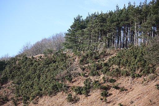
Near Steeple Cross. This photograph shows a view of the trail as it passes along the edge of the forested area between Steeple Cross and Dale Town Common. The picture was taken looking in a south-easterly direction towards Dale Town Common.
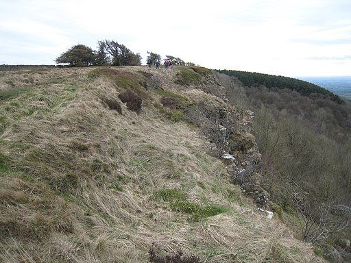
Boltby Scar from the Cleveland Way in the Hambleton Hills near Boltby Forest. This photograph shows a view of a section of Boltby Scar taken from the Cleveland Way long-distance footpath as it passes by Hambleton Mosses. A part of South Woods can be seen on the right-hand side of the image. A gate (leading to the footpath that goes to the junction of Cleveland Road and Wethercote Lane) is just visible to the left of the trees seen on the horizon. The picture was taken looking in a southerly direction towards Hill Fort Windypit.
The trail on Little Moor. The long distance path follows the plateau of the Hambleton Hills for many miles. It is all easy walking along a wide turfed drove road as typified here in the view north from Little Moor towards Black Hambleton Moor.
Near Spring Wood. This photograph shows a view of part of the footpath between Slapewath and Airy Hill Farm. The path runs along the edge of the tree-line (shown on the right-hand side of the picture - Spring Wood) above the (now disused) quarry that can be seen in the foreground. This picture was taken at a point half-way up the climb from Slapewath looking in a north-westerly direction towards the viewing point at the top. Just after the climb, the path heads north along the contour lines until it turns right in order to go to Airy Hill Farm
The Cleveland Way, the path to Highcliff Nab. This picture shows the trail heading in an easterly direction towards Highcliff Woods (on the horizon) and Highcliff Nab (horizon - left). Highcliffe Farm can be seen to the left of the boundary wall. The moorland area known as Codhill Heights can be seen on the horizon - to the right-hand side of the picture.
Near Thimbleby Moor. This photograph shows the footpath as it passes by Thimbleby Moor near Osmotherley. Vehicles parked in the Square Corner car park on the Osmotherley/Hawnby road can just be seen in the distance. The picture was taken looking in a northerly direction towards Jenny Brewster's Gill.
Approaching Spa Wood. Showing the trail as it edges around Guisborough Woods in order to make its way in a north-easterly direction towards Spa Wood. It then winds its way to the small village of Charltons. Notice the deforestation of Guisborough Woods shown on the left-hand side of the wall.
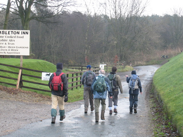
A group of walkers pass the Hambleton Inn on the A170 road. The trees in the background of the photograph are part of Scawton Moor Plantation. The Hambleton Inn lies on the northern side of the A170 road about 0.5 mile to the east of the Sutton Bank Visitors' Centre. The trail passes in front of the hotel and then swings left towards Cote Moor.
Video
Route Highlights
HelmsleyThe trail starts in the lovely market town of Helmsley in North Yorkshire with the fascinating medieval castle well worth visiting. |
Rievaulx AbbeyThe atmospheric abbey ruins at Rievaulx near Helmsley |
Saltburn-by-the-seaThe coastal stretch of the trail begins at the beautiful Victorian town of Saltburn-by-the-sea with its Grade II listed pier and splendid cliffs. |
WhitbyThe coastal town of Whitby has much to enjoy including the famous abbey and a plethora of fabulous fish & chip shops! |
Robin Hood's BayThe attractive fishing village of Robin Hood's Bay is a real highglight on the trail |
ScarboroughThe popular holiday resort of Scarborough is well worth spending a few hours in, with it's striking castle and lovely sandy bays the highlights in this attractive spa town. |
Roseberry ToppingBeloved landmark in the Tees Valley area this 1,049 feet (320 m) high Hill has a distinctive shape. |
Gisborough PrioryThe ruins of an Augustinian priory founded by the Bruce family, afterwards Kings of Scotland. They are dominated by the dramatic skeleton of the 14th century church's east end. |
FileyThe trail ends at the lovely seaside resort of Filey. Here you can visit Filey Brigg where there's some fascinating geology and wildlife including whales, seals and dolphins. |


