Walks Around Wootton Bassett
![]()
![]() The market town of Royal Wootton Bassett is located just west of Swindon in the county of Wiltshire.
The market town of Royal Wootton Bassett is located just west of Swindon in the county of Wiltshire.
Local walking highlights include Lydiard Park which lies just to the east of the town. The park includes a pretty lake and some pleasant woodland footpaths.
The town is also on the Wilts and Berks Canal which runs on to Melksham and Swindon.
This walk in the town visit the Jubilee Lake Nature Reserve on the northern side of the town. The reserve is a lovely place for a stroll with nice footpaths around the small lakes, woodland trails and lots of wildlife to look out for. You can start the walk from the car park just east of the lake and then follow a footpath along the Thunder Brook west to the lake.
Postcode
SN4 7JB - Please note: Postcode may be approximate for some rural locationsWootton Bassett Ordnance Survey Map  - view and print off detailed OS map
Wootton Bassett Open Street Map  - view and print off detailed map
Wootton Bassett OS Map  - Mobile GPS OS Map with Location tracking
Wootton Bassett Open Street Map  - Mobile GPS Map with Location tracking
Walks near Wootton Bassett
- Swindon Canal Circular Walk - A nice circular walk around Swindon, visiting the Wilts and Berks Canal, the Old Town Railway Path, Lawns Park and Queen's Park
- Wilts and Berks Canal - Enjoy a stroll along this pleasant section of the Wilts and Berks Canal in Swindon
- Melksham - This Wiltshire town has some lovely waterside walking trails along the tranquil River Avon and the Kennet and Avon Canal to the south
- Chiseldon and Marlborough Railway Path - This is a nice easy cycle or walking route along the now disused Chiseldon and Marlborough Railway.
It starts in Marlborough where you cross the River Kennet and head into the countryside along the path - Coate Water Country Park - This is a short circular walk around the delightful Coate Water Country Park in Swindon
- Mouldon Hill Country Park - This pretty country park near Swindon has some nice footpaths to follow through the site
- Shaw Forest Park - Enjoy some nice walking trails in this community woodland in Swindon
- Barbury Castle Country Park - Barbury Castle Country Park is a Scheduled Ancient Monument, Local Nature Reserve in the North Wessex Downs Area of Outstanding Natural Beauty
- Hackpen Hill - This circular walk visits the Hackpen White Horse hill figure on the Marlborough Downs.
- Ridgeway Circular Walk - Aldbourne - This circular route on the Wiltshire Downs explores the area around the village of Aldbourne
- Chiseldon Timberland Trail - This short easy cycle or walk trail runs from Swindon to Chiseldon along the old Swindon to Marlborough railway line.
The trail starts near Swindon Country Cricket Ground and heads to the lovely Coate Water Country Park where you can hire boats or try your hand at the crazy golf - Lydiard Park - Located on the edge of Swindon is this splendid park with 260 acres of lawns, woodlands and pasture for visitors to walk or cycle through
- Stanton Country Park - Explore this 74-hectare country park and Local Nature Reserve located near Swindon
- Liddington Hill - This circular walk uses the Ridgeway and the Aldbourne Circular Walk to climb Liddington Hill near Swindon
Pubs/Cafes
The on site Jubilee Lake Tea Room sells a good range of meals and snacks.
The Royal Wootton Bassett is located just to the south east of the reserve. They serve excellent tapas dishes and fine Sunday roast. There's also a nice garden area to relax in on warmer days. You can find them at postcode SN4 7HT.
Dog Walking
The reserve is dog friendly and the Royal Wootton Bassett mentioned above is dog friendly outside.
Photos
Jubilee Lake, Wootton Bassett. The lake was created around the time of the Great War when the Thunder Brook was dammed. It is now a popular leisure facility for anglers, dog-walkers and joggers.
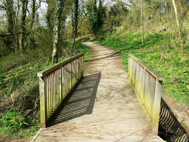
The bridge at Thunder Brook. Thunder Brook rises under a kilometre north-east of here and flows west through a small valley into an artificial lake created nearly 100 years ago. The brook continues on its way from the lake and joins the larger Brinkworth Brook at SU037834. Brinkworth Brook itself flows into the River Avon at ST974830.
Jubilee Lake and residents. Improvements to the lake are being carried out at the western end of the lake. A few of the coots and mallard that live here can be seen.


