Swindon Canal Circular Walk
![]()
![]() A nice circular walk around Swindon, visiting the Wilts and Berks Canal, the Old Town Railway Path, Lawns Park and Queen's Park. It's about a 5 mile walk with waterside trails, nature reserves and nice views of the surrounding countryside.
A nice circular walk around Swindon, visiting the Wilts and Berks Canal, the Old Town Railway Path, Lawns Park and Queen's Park. It's about a 5 mile walk with waterside trails, nature reserves and nice views of the surrounding countryside.
You can pick up the canal towpath in the Kingshill area of Swindon, just a short distance from the tourist information centre and the train station.
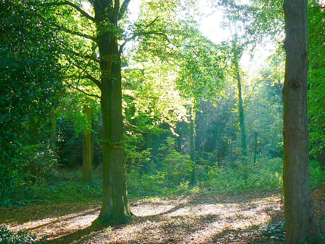
Follow the canal south west until you come to the Rushy Platt Nature Reserve on the River Ray. Here you can pick up the Old Town Railway Path and follow the shared cycling and walking trail east to Lawns Park. The pretty park has some nice footpaths through woodland and around a lake. See the video below for an aerial view of the park.
After exploring Lawns Park you head past Queen's Park which also has a nice lake and a diverse range of ornamental trees and shrubs. Shortly after you pass the tourist information centre and return to the canal.
You can extend your walking in the Swindon area by heading to Stanton Country Park or Mouldon Hill Country Park where there are some nice cycling and walking trails to try.
You could also enjoy a climb to Liddington Hill for great views over the surrounding area.
Swindon Canal Circular Walk Ordnance Survey Map  - view and print off detailed OS map
Swindon Canal Circular Walk Open Street Map  - view and print off detailed map
Swindon Canal Circular Walk OS Map  - Mobile GPS OS Map with Location tracking
Swindon Canal Circular Walk Open Street Map  - Mobile GPS Map with Location tracking
Pubs/Cafes
On the walk you could stop off at the Hall & Woodhouse Wichelstowe. The pub is situated in a lovely spot next to the canal and includes a fine interior with canal memorabilia decorating the pub. It even includes a canal boat cleverly nestled into the design of this modern pub. They serve good quality food and have a nice garden area next to the canal. You can find them at the southern end of the canal at Peglars Way with a postcode of SN1 7DA for your sat navs. There is a parking area and they are also dog friendly.
Further Information and Other Local Ideas
On the southern outskirts of the town you'll find Coate Water Country Park where there are some fine waterside trails and lots of wildlife to see. On the edge of the park you could also pay a visit to the fascinating Richard Jeffries Museum. Jeffries was a Victorian nature writer with a passion for the English countryside. He even gave us a name for it all: wild life. He was born in Swindon at Coate in the delightful 17th century thatched house which is now a museum to his life and work. The house is also surrounded by lush gardens making it a lovely place for a stroll near the town. You can find the museum at postcode SN3 6AA, just to the north east of Coate Water.
Just to the north east you could pick up the Highworth Walk where you can visit the 17th century Hannington Hall and enjoy the Georgian architecture in the pleasant market town of Highworth.
To the west there's neighbouring Wootton Bassett where you could visit the Jubilee Lake Nature Reserve on the northern side of the town. There's some pleasant waterside footpaths with lots of wildlife to see here.
For more walking ideas in the area see the Wiltshire Walks page.
Cycle Routes and Walking Routes Nearby
Photos
Old town railway path. The Midland and South Western Junction Railway ran along this track from the 19th century until the 1970s. Although the line closed to passenger traffic in 1961 this section, which ran from Rushey Platt to Swindon Old Town, remained open for freight traffic shipping materials for the construction of the M4 motorway in the early 1970s. It is now part of the National Cycle Network. The path leading down to the left provides access to a restored section of the Wilts & Berks canal.
Rushy Platt Nature Reserve. This is a remnant of the marshland that used to cover a lot of the countryside on the south side of Swindon. Now a nature reserve managed by the Wiltshire Wildlife Trust it is one of the last homes in the area for water voles. The watercourse is the River Ray. The high ground to the rear of the marsh is the embankment of the former Midland and South Western Junction Railway (M&SWJR).
Lawns Park Woodland. There was a slight mistiness in the air on this day which caught the sunlight breaking through the tree canopies.
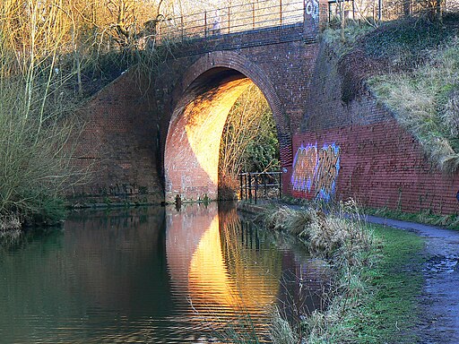
Bridge over the Wilts and Berks canal, Swindon. The bridge was built about 1880 for the Midland and South Western Junction Railway.


