All Stretton Walks
1.9 miles (3 km)
![]()
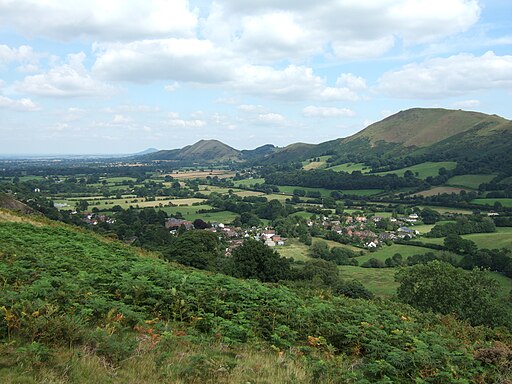
![]() This pretty little Shropshire based village lies just to the north of Church Stretton in the Shropshire Hills AONB.
This pretty little Shropshire based village lies just to the north of Church Stretton in the Shropshire Hills AONB.
This circular walk climbs to the viewpoint at Nover's Hill from the village. The hill lies just to the south west of the settlement and is a pleasant walk to try in the area. You can follow footpaths up towards the 305 metre high summit where there are some glorious views over the village to the surrounding hills and countryside.
To continue your walking in the area head south to visit one of the local highlights at the National Trust's Carding Mill Valley. This path will take you up to the Long Mynd where there is a fantastic ridge top walk with more stunning views to enjoy.
All Stretton Ordnance Survey Map  - view and print off detailed OS map
All Stretton Open Street Map  - view and print off detailed map
All Stretton OS Map  - Mobile GPS OS Map with Location tracking
All Stretton Open Street Map  - Mobile GPS Map with Location tracking
Walks near All Stretton
- Church Stretton - This attractive market town is a great place for exploring the Shropshire Hills Area of Outstanding Natural Beauty
- Ratlinghope - This small Shropshire village is nestled in splendid spot within the Long Mynd and Stiperstones AONB
- Caer Caradoc - Climb to the 1500 ft (459 m) summit of this distinctive hill in the Shropshire Hills AONB
- Long Mynd - This circular walk takes you to Pole Bank, the highest point on the Long Mynd in the Shropshire Hills AONB
- Carding Mill Valley - Visit a lovely reservoir and waterfall on this short walk in the Shropshire Hills AONB
- Jack Mytton Way - This is a splendid walk or mountain bike ride through Shropshire from Cleobury Mortimer to Llanfair Waterdine
- Shropshire Way - This walk takes you through some of the most beautiful countryside in Shropshire
- Ragleth Hill - This walk climbs to Ragleth Hill above Church Stretton in the Shropshire Hills
- Wenlock Edge Circular Walk - This circular walk from Much Wenlock explores the eastern end of the beautiful Wenlock Edge
- Wenlock Edge - Wenlock Edge runs from Craven Arms to Much Wenlock, in the Shropshire Hills AONB
- Ashes Hollow - This walk explores Ashes Hollow near the villages of Church Stretton and Little Stretton in the Shropshire Hills.
- Little Stretton - The village of Little Stretton sits in an enviable position in the Shropshire Hills
- Adstone Hill - This waymarked circular walk climbs to Adstone Hill on the Long Mynd near Ratlinghope in the Shropshire Hills.
- Wistanstow and Flounders Folly - This Shropshire based village lies just to the north of Craven Arms in the Shropshire Hills.


