Camborne Walks
![]()
![]() This Cornish town is located a few miles south of the coast near Redruth.
This Cornish town is located a few miles south of the coast near Redruth.
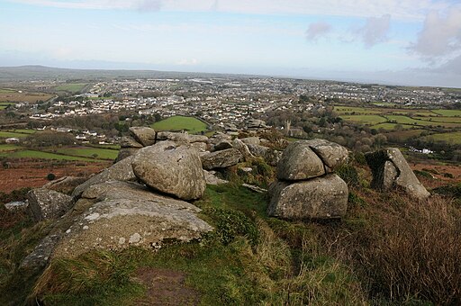
Local walking highlights include the climb to Carn Brea where you'll find an ancient hillfort and some fine views over the town. In this area you can also pick up the popular Great Flat Lode Trail. The circular cycling and walking route explores Cornwall's heritage mines, exposing you to Camborne's rich copper mining history.
To the north there's the splendid Tehidy Country Park where you'll find some peaceful woodland trails and lots of wildlife. Near here there's also the coast where you can pick up the South West Coast Path National Trail and visit to Godrevy Head and the beaches at Portreath.
This walk from the town follows footpaths up to the ancient hill fort at Carn Brea. Here you will find the Basset Monument and some excellent views over the surrounding coast and countryside.
Camborne Ordnance Survey Map  - view and print off detailed OS map
Camborne Open Street Map  - view and print off detailed map
Camborne OS Map  - Mobile GPS OS Map with Location tracking
Camborne Open Street Map  - Mobile GPS Map with Location tracking
Walks near Camborne
- Carn Brea - This walk explores the ancient Carn Brea hill fort and the Bassett Monument above Redruth in Cornwall.
- Tehidy Country Park - Explore 250 acres of peaceful woods and lakes at Tehidy, near Portreath, in Cornwall
- Great Flat Lode Trail - This is a short, circular off road walk or cycle that circles the historic hilltop site of Carn Brea
- Carn Marth - This circular walk visits the Carn Marth outdoor theatre and the surrounding quarries in the Redruth area of Cornwall.
- Poldice Valley - The Poldice Valley is located in southwest Cornwall near Redruth.
- Gwennap Pit - This walk visits Gwennap Pit in Busveal, Cornwall
- Godrevy Head - Explore Godrevy Head and enjoy wonderful views of St Ives Bay and the Cornish coast on this splendid coastal walk
- Hayle Estuary - Enjoy a walk or cycle around the beautiful Hayle Estuary RSPB reserve in Cornwall
- Mineral Tramways Trail - Also known as the Bissoe Trail, this is a fabulous, largely traffic free ride or walk, from Portreath to Devoran
- Redruth - This Cornish town has some nice walking trails exploring the settlement's rich mining history
- Truro - Truro is notable as Cornwall's only city and mainland Britain's southernmost city
- Gwithian - This walk explores the area around the village of Gwithian on the West Cornwall coast.
- Portreath - This north Cornish fishing village has a pretty harbour and two popular sandy beaches
Pubs/Cafes
The Beacon Inn is a good choice for some post walk refreshment. The friendly inn is set in the old mining district above Camborne and includes an interesting mural depicting local mining scenes. Outside there is a beer garden used in summer for barbecues and a cider frestival. They are located at postcode TR14 7SE for your sat navs.
Further Information and Other Local Ideas
On the walk you could take a detour to visit the King Edward Mine Museum. Here you can learn all about the area's mining heritage at a former working mine. A guide will take you around the Cornish Tin Mill, demonstrating the unique equipment in action. You can find them at postcode TR14 9HW for your sat navs.
Photos
Camborne Commercial Square. Commercial Square is at the heart of Camborne town centre and the fountain at the centre of the photograph is a well-known local meeting place. The lamp standard on the fountain dates from 1890. A more modern invader is the CCTV camera on a high pole keeping a watchful eye from the background.
Camborne Parish Church. This church is dedicated to Saints Martin and Meriadoc. The church has had a long an complex history with rebuilding work often reincorporating much of the earlier fabric of the church.
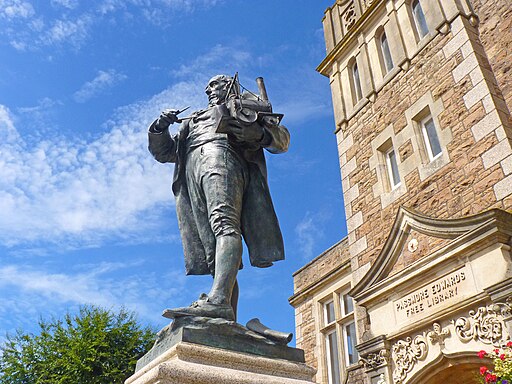
Richard Trevithick Statue, Camborne. Statue of Richard Trevithick holding a model of a steam locomotive and a pair of dividers. The statue looks up Beacon Hill which is where he first tested his theories. Trevithick was a British inventor and an early pioneer of steam-powered road and rail transport. His most significant contributions were the development of the first high-pressure steam engine and the first working railway steam locomotive.


