Garn Boduan
![]()
![]() This walk takes you up to the Iron Age Hill fort of Garn Boduan on the Llyn Peninsula near Nefyn.
This walk takes you up to the Iron Age Hill fort of Garn Boduan on the Llyn Peninsula near Nefyn.
You can start the walk from Nefyn and then follow trails south up to the 279 metre high summit. From here there are some excellent views over the countryside to the coast. On the way there are some peaceful woodland trails to enjoy in the Garn Boduan Forest which surrounds the fort. There's also lots of lovely heather and interesting rock formations to see.
To extend the walk you could head east to visit Mynynd Nefyn where there are more pleasant trails and views.
Garn Boduan Ordnance Survey Map  - view and print off detailed OS map
Garn Boduan Open Street Map  - view and print off detailed map
Garn Boduan OS Map  - Mobile GPS OS Map with Location tracking
Garn Boduan Open Street Map  - Mobile GPS Map with Location tracking
Pubs/Cafes
In Nefyn there's the Nanhoron Arms for some post walk refreshment. There are two nice bars here and a garden for warmer days. You can find them on St Davids Road at postcode LL53 6EA.
Further Information and Other Local Ideas
Just to the north you can pick up the popular Llyn Coastal Path and enjoy a walk along the beaches to the wonderful Porthdinllaen.
Cycle Routes and Walking Routes Nearby
Photos
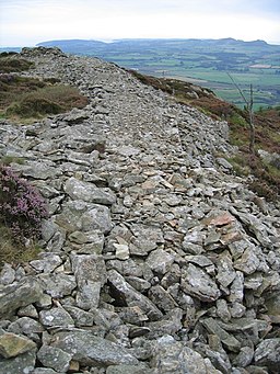
The substantial remains of the stone wall of the hillfort on Garn Boduan. In the distance, beyond the end of the wall, is Mynydd Tir-y-cwmwd, the headland above Llanbedrog.


