Llangollen Round Circular Walk
![]()
![]() Explore the beautiful area around the town of Llangollen, in Denbighshire, on this circular walk, devised to raise funds for the Cancer Research UK charity. This is a challenging walk visiting every summit around the Vale of Llangollen with views of Snowdonia, the mid-Wales mountains, the River Dee Valley and the Shropshire Hills.
Explore the beautiful area around the town of Llangollen, in Denbighshire, on this circular walk, devised to raise funds for the Cancer Research UK charity. This is a challenging walk visiting every summit around the Vale of Llangollen with views of Snowdonia, the mid-Wales mountains, the River Dee Valley and the Shropshire Hills.
Highlights on the walk include the Pontcysyllte Aqueduct (video below) - the longest and highest aqueduct in Britain.
You will also pass several old slate quarries and visit Moel Y Gaer (Welsh for 'bald hill of the fortress') an Iron Age hill fort on the summit of Llantysilio Mountain.
To extend your walking in the area you could enjoy a waterside stroll along the Llangollen Canal and visit the beautiful Horseshoe Falls.
The route passes close to the wonderful Castell Dinas Bran. There are fabulous views over the Dee Valley from the elevated position of the medieval castle ruins.
Please click here for more information
Llangollen Round Ordnance Survey Map  - view and print off detailed OS map
Llangollen Round Open Street Map  - view and print off detailed map
Llangollen Round OS Map  - Mobile GPS OS Map with Location tracking
Llangollen Round Open Street Map  - Mobile GPS Map with Location tracking
Further Information and Other Local Ideas
Near the route you can visit the worthy villages of Glyn Ceiriog and Llanarmon Dyffryn Ceiriog where you can explore the beautiful Upper Ceiriog Valley. The splendid Berwyn Mountains can also be explored on the North Berwyn Way in this area.
The Dee Valley starts/finishes in the town. It will take you west to the settlements of Corwen and Carrog on a challenging 15 mile waymarked trail.
Cycle Routes and Walking Routes Nearby
Photos

Pontcysyllte Aqueduct. Thomas Telford's iron trough aqueduct carrying the Ellesmere branch of the Shropshire Union Canal (the Llangollen Canal) 132 feet above the River Dee. There is a walkway over the aqueduct, which now carries the Offa's Dyke Path.

Moel y Gaer. An Iron Age hillfort, on a 339 m outcrop of the Clwydian Range, has a splendidly commanding view of a huge area. A chain of intervisible forts runs the length of the Clwydian Hills.

Racing track, Llantysilio Mountain

Ford at World's End

Slate Spoil Heap opposite Moel y Faen. This is the top of the spoil heap across the minor road from the Moel y Faen quarry. The quarry itself is behind the camera. On the 1879 O.S. map a branch of the main quarry tramway is shown crossing the minor road and extending out on to this heap, which probably explains the curved line between the smaller piles of slate seen in this photo. There is no sign of the tramway today.

Moel Morfydd - one of the hills on the northern side of the route. Shown here is the trig point on the summit of Moel Morfydd; looking east, with a heather fire on the Eglwyseg Hills beyond.

Small Lake on Llantysilio Mountain

Moel Fferna summit. There a fine views towards Snowdon from the summit of this hill which sits at the south western tip of the trail.
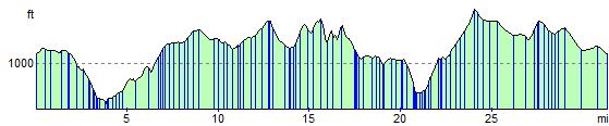
Elevation Profile