Mottram Hall Walks
![]()
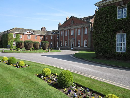
![]() This Grade II listed hall includes 270 acres of beautiful landscaped gardens. The 18th century hall is located just northeast of the village of Mottram St. Andrew, Cheshire.
This Grade II listed hall includes 270 acres of beautiful landscaped gardens. The 18th century hall is located just northeast of the village of Mottram St. Andrew, Cheshire.
You could visit the hall for afternoon tea and then enjoy a stroll around the impressive grounds.
This circular walk takes you through the countryside surrounding the hall following public footpaths along the River Bollin and through Mottram Wood.
To continue your walking near Mottram Hall you could head south to visit the lovely village of Prestbury or west to climb to the woods and viewpoint at Alderley Edge.
Postcode
SK10 4QT - Please note: Postcode may be approximate for some rural locationsPlease click here for more information
Mottram Hall Ordnance Survey Map  - view and print off detailed OS map
Mottram Hall Open Street Map  - view and print off detailed map
Mottram Hall OS Map  - Mobile GPS OS Map with Location tracking
Mottram Hall Open Street Map  - Mobile GPS Map with Location tracking
Walks near Mottram Hall
- Prestbury - This delightful Cheshire based village is a fine place for an easy stroll
- Alderley Edge - This lovely circular walk explores the beautiful National Trust owned area of Alderley Edge
- Bollington - This circular walk explores the area surrounding the Cheshire town of Bollington
- White Nancy - This walk climbs to unusual structure of White Nancy overlooking the town of Bollington in Cheshire
- Macclesfield Canal - Follow the towpath of the Macclesfield Canal from Marple to Kidsgrove on this waterside walk in Cheshire
- Tegg's Nose Country Park - This lovely country park in Macclesfield has splendid views of the Peak District National Park and the Cheshire plain
- Gritstone Trail - This beautiful, challenging walk runs through the Peak District from Disley to Kidsgrove.
The walk begins at the train station at Disley and soon comes to the wonderful Lyme Park (video below) with its mansion house and Medieval deer park - Poynton - This circular walk from Poynton visits Poynton Park and the Macclesfield Canal
- Lyme Park - This is a circular walk through the splendid Lyme Park in Disley, Cheshire
- Macclesfield to Marple - Middlewood Way - Follow the Middlewood Way - a lovely off road cycle and walking path running from Macclesfield to Marple and passing by the Macclesfield Canal.
- Hare Hill - This walk visits the National Trust's lovely Hare Hill Gardens before heading to the nearby Alderley Edge for fine views over the Cheshire Plain.
The walk starts from the Hare Hill car park which is located between Macclesfield and Alderley Edge - Wizard Trail - This lovely trail takes you through some attractive Cheshire countryside and is ideal for an afternoon's cycle.
Starting at Alderley Edge highlights on the route include the Wizard's well, the 15th century Alderley mill and National Trust owned Hare Hill. - Wilmslow - This walk from Wilmslow visits the popular Carrs Park before following the River Bollin to the nearby Styal Country Park and Woods
- North Cheshire Way - Starting at Hooton Station, near Ellesmere Port, follow the North Cheshire Way through Frodsham, Northwich, Knutsford and Wilmslow to the finish point at Disley
- Bollin Valley Way - Follow the River Bollin from Macclesfield to Partington on this delightful waterside walk through Greater Manchester and Cheshire.
The walk starts at the Macclesfield Riverside Park and follows the river through Prestbury, Wilmslow, Hale and Bowdon to Partington on the Manchester Ship Canal.
On the route you will pass the 18th century Grade II listed Mottram Hall and National Trust owned Dunham Massey - Lamaload Reservoir - This circular walk takes you around the pretty Lamaload Reservoir near Macclesfield in the Peak District National Park
- Lindow Common - This walk visits Lindow Common Nature Reserve in Wilmslow, Cheshire.
Further Information and Other Local Ideas
On the western side of Wilmslow you will find Lindow Common Nature Reserve. The small common is a nice place for a stroll with pleasant footpaths taking you around birch woodland and heathland. There's also lots of wildlife to see on the common's pretty lake.


