Ottery St Mary Walk
![]()
![]() This pretty East Devon town has some nice easy walks along the River Otter which runs past the settlement. It's also well known for the lovely 14th century St. Mary Church which includes a noteworthy astronomical clock.
This pretty East Devon town has some nice easy walks along the River Otter which runs past the settlement. It's also well known for the lovely 14th century St. Mary Church which includes a noteworthy astronomical clock.
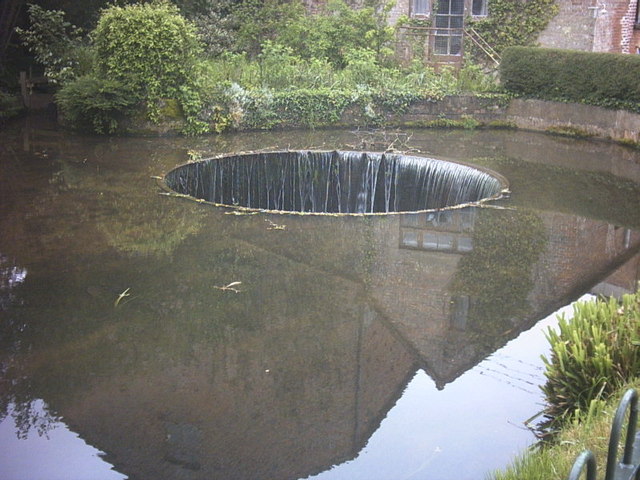
This circular walk from the town takes you along the River Otter to the nearby village of Tipton St John. The route runs for about 5 miles along public footpaths on both sides of the river. It's a fairly flat path with some small climbs along the way. The town is very pretty with a mill stream, an unusual tumbling weir, picturesque buildings and the 19th century St Saviour's Bridge, spanning the river.
The walk starts to the west of the town centre where you can pick up a riverside footpath heading south. It will take you past Salston Barton and Fluxton before arriving at Tipton St John.
After exploring the village you pick up a footpath heading north to rejoin with the river. You can then follow a path along the eastern side of the water to return to Ottery St Mary.
Ottery St Mary Ordnance Survey Map  - view and print off detailed OS map
Ottery St Mary Open Street Map  - view and print off detailed map
Ottery St Mary OS Map  - Mobile GPS OS Map with Location tracking
Ottery St Mary Open Street Map  - Mobile GPS Map with Location tracking
Pubs/Cafes
The London Inn is a good choice for some post walk refreshments. The friendly pub does good food and also has an outside area if the weather is good. It also has an interesting history daing back to the middle of the 17th century when it was a coaching inn. You can find the pub in the centre of the town on 4 Gold Street with a postcode of EX11 1DG for your sat navs.
Dog Walking
The river trails make for a nice dog walk and the London Inn mentioned above is also dog friendly.
Further Information and Other Local Ideas
The Honiton Walk starts in the nearby town and follows a section of the Exeter to Honiton Way to Ottery St Mary. The attractive town has an is regarded as the antiques capital of the south west with a rich history in lace making and pottery.
The town is located close to two AONB'S. You can explore the East Devon AONB on the long distance East Devon Way. There's also the Blackdown Hills AONB to the east.
Head south from the town and you will soon come to the coast. Here you can enjoy some lovely coastal walks on the Sidmouth to Beer Walk, the Sidmouth to Budleigh Salterton Walk and the Sidmouth to Ladram Bay Walk. At Budleigh you can also explore the Otter Estuary where there's lots of wildlife to look out for.
For more walking ideas in the area see the Devon Walks page.
Cycle Routes and Walking Routes Nearby
Photos
St Saviour's Bridge, Ottery St Mary Built in 1851 by Joseph Butler & Co, Stanningley Iron Works, near Leeds, 1851. Later rebuilt for modern loadings.
Tumbling weir tailrace, Ottery St Mary. The weir is quite photogenic but it wouldn't function at all if the water had nowhere to go. The weir is the overflow from the mill leat back to the river and now that the two mills it fed do not use the water it is of more ornament than use.


