Port Talbot Walks
![]()
![]() This coastal town is located near Swansea in the county borough of Neath Port Talbot.
This coastal town is located near Swansea in the county borough of Neath Port Talbot.
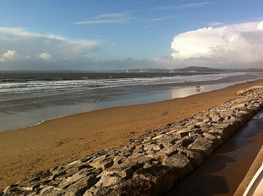
There's some excellent walking near the town with the Kenfig Pool Nature Reserve, Margam Country Park and the lovely Merthyr Mawr Sand Dunes local highlights. This walk takes you along Aberavon Sands in the town. The attractive sandy beach and promenade are a nice place for an easy stroll. The beach runs for 3 miles and is lined with a number of cafes and pubs where you could stop off for refreshments. There's good views north towards Baglan Bay and south towards Margam.
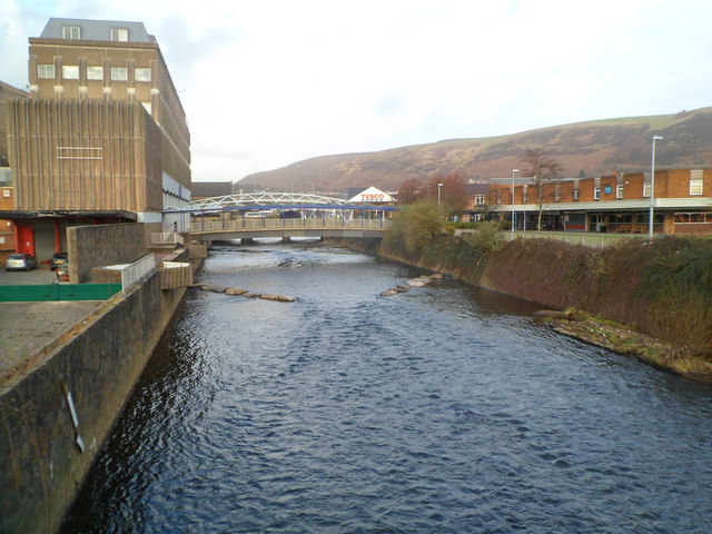
You could extend the walk by heading along the River Afan at the eastern end of the prom. A shared walking and cycling route runs along the river towards the docks.
Postcode
SA12 6AN - Please note: Postcode may be approximate for some rural locationsPort Talbot Ordnance Survey Map  - view and print off detailed OS map
Port Talbot Open Street Map  - view and print off detailed map
*New* - Walks and Cycle Routes Near Me Map - Waymarked Routes and Mountain Bike Trails>>
Port Talbot OS Map  - Mobile GPS OS Map with Location tracking
Port Talbot Open Street Map  - Mobile GPS Map with Location tracking
Walks near Port Talbot
- Kenfig Pool Nature Reserve - A lovely coastal walk around this national nature reserve near Porthcawl, Bridgend
- Merthyr Mawr Sand Dunes Walk - This walk visits the lovely Merthyr Mawr Warren National Nature Reserve on the South Wales coast
- Porthcawl Coastal Walk - A walk from Porthcawl to Ogmore by Sea along a lovely section of the Wales Coast Path
- Brombil Reservoir - This walk visits Brombil Reservoir and Brombil Woods near Port Talbot.
- Margam Country Park - This large country park includes the magnificent Margam Castle, an 18th Century Orangery with ornamental gardens and a Deer Park, all set within 1000 acres of beautiful countryside
- Bridgend Circular Walk - Starting at Ogmore Castle on the River Ogwr, follow this relativley flat route around the town of Bridgend, South Wales
- Bryngarw Country Park - This 120 acre country park is situated on the River Garw just north of Bridgend
- Rest Bay - This circular walk explores the area around the lovely Rest Bay in Porthcawl
- Afan Forest Park Country Park - Set in the beautiful Afan Valley in Neath Port Talbot, this 48-square-mile forest park has miles of cycling trails, walking trails and several fantastic mountain bike trails.
- Kilvey Hill - This circular walk climbs to the Kilvey Hill viewpoint in Swansea
- Ogwr Ridgeway Walk - Enjoy spectacular views of the Ogwr Fach, Garw and Llynfi valleys on this walk from Mynydd Maendy to Margam Country Park near Port Talbot
- Glamorgan Ridgeway Walk - Follow the Glamorgan Ridgeway from Margam Country Park, near Port Talbot, through beautiful upland and valley scenery, to Caerphilly Castle
- Swansea Canal - Enjoy an easy waterside cycle or walk along the Swansea Canal and River Tawe
- Swansea - Swansea has some great coastal walking with other nice trails to be found in the woods, country parks, reservoirs and canals nearby
Further Information and Other Local Ideas
To fine long distance trails pass through the area in the shape of the Ogwr Ridgeway Walk and the Glamorgan Ridgeway Walk. These are both good options for continuing your walking around Port Talbot.
Photos
Grade II* listed War Memorial, Port Talbot. Located inside Talbot Memorial Park, 55 metres ENE of the entrance gateway. The memorial is a bronze statue of the Angel of Victory standing on a granite plinth with bronze panels on the sides. The angel holds a laurel wreath in one hand and a small winged Victory (a representation of the Roman goddess of victory) in the other. Grade II* listed in April 2000.
Two river bridges. Looking upstream along the Afan towards a footbridge and High Street bridge behind it.


