Dumfries River Walk
![]()
![]() This market town is located near the mouth of the River Nith and Solway Firth about 15 miles from the border with England in Dumfries and Galloway.
This market town is located near the mouth of the River Nith and Solway Firth about 15 miles from the border with England in Dumfries and Galloway.
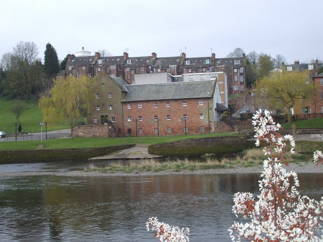
The town has strong associations with the poet Robert Burns who lived here in the late 1700s. You can visit the Robert Burns centre to find out more about his life and works in a series of exhibitions. The centre is housed in an 18th-century watermill, positioned in a lovely spot on the river.
This walk in the town takes you along the River Nith to Kingholm Quay.
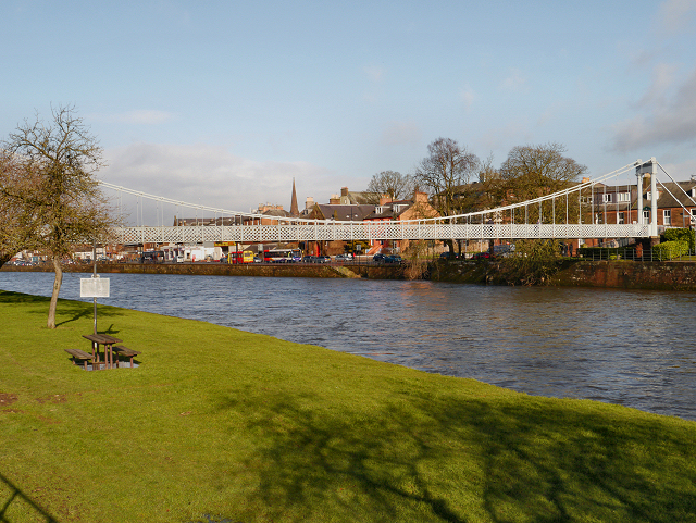
The walk starts at the Robert Burns Centre and follows a pleasant riverside walking and cycling path south for nearly 2 miles. On the way you will pass the pretty Dock Park, where you'll find the Octocentenary walk and a number of benches to rest and enjoy the view. There's also a series of bridges including the Kirkpatrick Macmillan bridge where you can cross to the other side and enjoy a nice view over the river to the surrounding Scottish hills.
To continue your walking around Dumfries head south west to explore Mabie Forest where there's miles of good walking and cycling trails to try. Near here there's also the waterside trails around Loch Arthur.
Scroll down for a list of walks near the town.
Postcode
DG2 7BE - Please note: Postcode may be approximate for some rural locationsDumfries River Walk Ordnance Survey Map  - view and print off detailed OS map
Dumfries River Walk Open Street Map  - view and print off detailed map
*New* - Walks and Cycle Routes Near Me Map - Waymarked Routes and Mountain Bike Trails>>
Dumfries River Walk OS Map  - Mobile GPS OS Map with Location tracking
Dumfries River Walk Open Street Map  - Mobile GPS Map with Location tracking
Walks near Dumfries River Walk
- Loch Arthur - This walk visits the Loch Arthur Community in Beeswing, Dumfries
- Mabie Forest - This expansive forest in Dumfries has miles of good walking paths and several mountain bike trails to try.
- Daer Reservoir - This walk visits Daer Reservoir in the Lowther Hills of South Lanarkshire in the Southern Uplands of Scotland
- Loch Ettrick - This walk visits the lovely Loch Ettrick near the village of Thornhill in Dumfries and Galloway.
- Crichope Linn - This walk visits the Crichope Linn waterfall near Gatelawbridge in Dumfries and Galloway.
- Drumlanrig Castle - The extensive grounds of this historic castle are a great place for outdoor enthusiasts
- Loch Ken - This walk explores the RSPB Ken-Dee Marshes Nature Reserve on Loch Ken in Dumfries and Galloway.
- Threave Gardens and Carlingwark Loch - This walk takes you from Castle Douglas to Carlingwark Loch and then on to the beautiful Threave Estate and Gardens.
- Rockcliffe to Kippford Walk - This circular walk takes you from the National Trust's Rockcliffe to nearby Kippford in Dumfries and Galloway
- Dalbeattie Forest - This large area of woodland in in Dumfries and Galloway is a great place for walking and cycling.
- Ae Forest - This route explores the Ae Forest in Dumfries and Galloway.
- Romans and Reivers Route - This long distance route follows the old Roman Roads from the Ae Forest to Hawick
- Lochmaben - This walk visits Castle Loch in the small town of Lochmaben in Dumfries and Galloway
- Sandyhills To Kippford Coastal Walk - This coastal walk takes you from Sandyhills to Rockcliffe and Kippford in Dumfries and Galloway.
- Burnswark Hill - This walk climbs to the fine viewpoint at Burnswark Hill near Lockerbie in Dumfries and Galloway.
Pubs/Cafes
Stop off for refreshments at the Riverside Bar in Dock Park. There's two outside seating areas include a terrace with open views over the Park and down to the River Nith. You can find them at postcode DG1 2RY for your sat navs.
Dog Walking
The riverside paths make for a pleasant dog walk. The Riverside Bar mentioned above is also dog friendly.
Further Information and Other Local Ideas
For cyclists the new Kirkpatrick C2C also passes through Dumfries. The epic Coast to Coast route runs across the south of Scotland from Stranraer to Eyemouth.
Photos
Kirkpatrick Macmillan bridge. This foot- and cycle-bridge, the lowest crossing point over the River Nith, was built in 2006. It is named after Kirkpatrick Macmillan, a local unsung hero who lived and worked at Keir Mill about 20 Km to the north-west of Dumfries. He is credited in 1839 with building the first bicycle, thereby initiating a quiet revolution in personal transport. It is the second new footbridge over the Nith to be built in recent years, the first being the Millennium Bridge NY9676 nearer the town centre.
The Robert Burns Centre, Dumfries Formerly a watermill. The top of the Camera Obscura can be seen above the left-hand roof of the terrace beyond.


