Laxton Walks
![]()
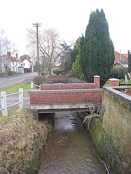
![]() This pretty village in Nottinghamshire is a nice place for country walks or a village stroll.
This pretty village in Nottinghamshire is a nice place for country walks or a village stroll.
The settlement is notable as England’s Last Open Field Village, meaning it still operates the medieval ‘open field’ farming system whereby the three fields are divided into strips. These strips are then worked by the local farmers under the jurisdiction of a Court Leet and jury.
The historic settlement includes many notable features including a 12th century church and a Norman motte and bailey castle.
This circular walk takes you to the neighbouring village of Egmanton. You'll follow a mixture of public footpaths and country lanes for a distance of just under 8 miles. There's nice countryside views and a series of farms on the way. You'll also pass the Beth Shalom Holocaust Centre which includes an exhibition centre with lecture theatre, and a Memorial Garden. It lies on the walk just west of the village.
Postcode
NG22 0SX - Please note: Postcode may be approximate for some rural locationsLaxton Ordnance Survey Map  - view and print off detailed OS map
Laxton Open Street Map  - view and print off detailed map
Laxton OS Map  - Mobile GPS OS Map with Location tracking
Laxton Open Street Map  - Mobile GPS Map with Location tracking
Walks near Laxton
- Edwinstowe - This Nottinghamshire based village sits in a pleasant spot, on the edge of Sherwood Forest near Mansfield
- Sherwood Forest Country Park - Explore 450 acres of peaceful woodland in this famous park and Nature Reserve in Nottinghamshire
- Clumber Country Park - Enjoy a peaceful walk or cycle around the fabulous Clumber Park in Worksop
- Thoresby Park - This walk visits the lovely Thoresby Park in Nottinghamshire
- Rufford Abbey Country Park - Visit Rufford Country Park near Mansfield and explore 150 acres of historic parkland
- Southwell Trail - This traffic free cycling and walking trail links Southwell to Bilsthorpe in the Sherwood Forest area of Nottinghamshire
- Vicar Water Country Park - Explore 200 acres of rare heathland, mature woodland and species rich grassland in this country park near Mansfield
- Worksop - This walk follows a section of the Chesterfield Canal from Worksop to Kiveton Park
- Creswell Crags - This walk takes you around this fascinating limestone gorge on the Derbyshire and Nottinghamshire border
- Mansfield - The area surrounding the market town of Mansfield has some excellent choices for walkers
- Sherwood Pines Forest Park - Enjoy several waymarked cycling and walking trails in this large woodland area in Mansfield
- Pleasley Pit Country Park - This former colliery site in Mansfield has been converted into a lovely country park and local nature reserve
- Pleasley Vale - This circular walk explores the wooded valley of Pleasley Vale on the Derbyshire and Nottinghamshire border.
- Walesby Forest - This circular walk from the Nottinghamshire village of Walesby explores the countryside and woodland surrounding the settlement
Pubs/Cafes
The Dovecote Inn is a historic pub where you can enjoy some refreshments after your walk. It also doubles as the visitor and heritage centre where you can learn all about the history of the village. You can find them at postcode NG22 0SX.
Photos
High Street, Laxton. It is thought to be the namesake of the town of Lexington, Massachusetts, and probably all the other towns named Lexington in the United States


