Sutton in Craven and Lund's Tower Walk
![]()
![]() This North Yorkshire based village is located near Keighley and Skipton in the Craven District of the county.
This North Yorkshire based village is located near Keighley and Skipton in the Craven District of the county.
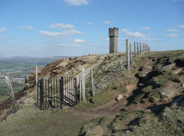
This walk from the village takes you up to Wainman's Pinnacle and Lund's Tower, a folly and viewpoint located just south west of the settlement.
You can start the walk in the village at Sutton Park, a delightful local park with green lawns and flower beds. From near here you can pick up footpaths heading south west through the countryside to the tower. The monument was built by James Lund, the the son of William Lund, the owner a large textile manufacturing business. It is thought to have been constructed either to celebrate the birth of Lund's daughter Ethel or to commemorate the 1887 jubilee of Queen Victoria.
The route then continues to Wainman's Pinnacle which lies just to the west of Lund's tower. The monument stands on Earl Crag at a height of 354 metres. The two neighbouring towers are often referred to as the Salt and Pepper Pots.
Postcode
BD20 7JS - Please note: Postcode may be approximate for some rural locationsSutton in Craven Ordnance Survey Map  - view and print off detailed OS map
Sutton in Craven Open Street Map  - view and print off detailed map
Sutton in Craven OS Map  - Mobile GPS OS Map with Location tracking
Sutton in Craven Open Street Map  - Mobile GPS Map with Location tracking
Walks near Sutton in Craven
- Silsden - This West Yorkshire town is positioned on the River Aire and Leeds and Liverpool Canal near Skipton and Keighley.
- Silsden to Skipton Canal Walk - Enjoy and easy waterside stroll along the Leeds and Liverpool Canal on this walk from Silsden to Skipton
- Skipton Canal - This is a popular walk taking you from Skipton to Gargrave along the Leeds and Liverpool Canal
- Ilkley to Addingham - This circular walk takes you from Ilkley to Addingham along the River Wharfe
- Bolton Abbey - Explore the huge estate surrounding the ruins of this 12th-century Augustinian monastery
- Cow and Calf and Twelve Apostles - This circular walk visits two of the higlights of Ilkley Moor and Burley Moor in West Yorkshire.
The walk starts from the Cow and Calf parking area on Hangingstone Road, just to the south east of the town of Ilkley - Burley in Wharfedale - This Yorkshire based village is in a great spot for exploring the famous Ilkley Moor and the beautiful Wharfedale
- Leeds and Liverpool Canal - Enjoy waterside cycling and walking along Britain's longest single canal
- Keighley - This circular walk from the West Yorkshire town of Keighley makes use of the waymarked Worth Way to visit nearby Haworth and Penistone Hill Country Park
- Embsay Reservoir - Enjoy a short stroll around this reservoir in North Yorkshire
- Beamsley Beacon - This short climb in the Yorkshire Dales visits Beamsley Beacon which is also known as Howber Hill
- Shipley Glen - Enjoy a short walk through this delightful glen near Bradford
- Horton Bank Country Park - This pretty country park in Bradford has some well laid out walking trails to try.
- Chellow Dene Reservoir - Visit this lovely beauty spot on the outskirts of Bradford on this easy circular walk in West Yorkshire
- Bradford Millennium Way - This long distance, waymarked circular walk takes you on a tour of some of most beautiful countryside, pretty villages and attractive moorland in the Bradford area of West Yorkshire.
The walk starts on Shipley Green, just north of Shipley town centre - Elslack Reservoir - This circular walk visits Elslack Reservoir in North Yorkshire near Skipton.
- Lothersdale - This North Yorkshire village is located near Earby and Skipton on the Pennine Way.
Further Information and Other Local Ideas
Just to the north you can pick up the Leeds and Liverpool Canal and enjoy a stroll along the towpath into neighbouring Silsden.
To the north west is Lothersdale where you can enjoy a climb to Pinhaw Beacon for some excellent views of the area. The village also includes a historic pub worthy of some investigation.
Photos
Gateway to Lund's Tower. A custom-made kissing gate with the initials LTS, which I think stands for Lund's Tower Society.


