Formartine and Buchan Way Cycle and Walk Map
![]()
![]() A super off road cycling and walking trail through Aberdeenshire following a dismantled railway line. The route runs from Dyce to Fraserburgh with an optional section to Peterhead. Highlights on the route include Aden Country Park where you will find the Aberdeenshire Farming Museum, forest walks and a ruined country house. The path also passes the peaceful Pitfour Lake, the 13th century ruined abbey at Deer Abbey (see video), the Strichen White Horse and the ancient Strichen Stone Circle.
A super off road cycling and walking trail through Aberdeenshire following a dismantled railway line. The route runs from Dyce to Fraserburgh with an optional section to Peterhead. Highlights on the route include Aden Country Park where you will find the Aberdeenshire Farming Museum, forest walks and a ruined country house. The path also passes the peaceful Pitfour Lake, the 13th century ruined abbey at Deer Abbey (see video), the Strichen White Horse and the ancient Strichen Stone Circle.
The route is waymarked with the letters F & BW on a red railway logo.
The start point at Dyce is located a few miles north west of the city of Aberdeen.
Formartine and Buchan Way Ordnance Survey Map  - view and print off detailed OS map
Formartine and Buchan Way Open Street Map  - view and print off detailed map
Formartine and Buchan Way OS Map  - Mobile GPS OS Map with Location tracking
Formartine and Buchan Way Open Street Map  - Mobile GPS Map with Location tracking
Further Information and Other Local Ideas
Towards the Fraserburgh end of the route you could take a detour east to visit the lovely Loch of Strathbeg. The area includes an RSPB visitor centre, wildlife reserve and several species of water loving birds to look out for on the loch.
Cycle Routes and Walking Routes Nearby
Photos

Formartine and Buchan Way. Between Deer Abbey and Maud. The trail passes through a variety of landscapes, including farmland, woodland, and wetland, supporting diverse flora and fauna throughout the year. Wildflowers such as meadowsweet, tufted vetch, and red campion grow along the verges, attracting butterflies including the small tortoiseshell, painted lady, and peacock. In more open areas, orchids can sometimes be found, while gorse and broom provide shelter for birds and insects. Wooded sections feature rowan, birch, and Scots pine, with ferns and mosses thriving in shaded areas.

Information board on the route. The route is home to a range of birdlife, including skylarks, yellowhammers, and linnets in farmland areas, while buzzards and kestrels can be seen soaring overhead. Red kites are occasionally spotted, and barn owls may be seen hunting at dusk. Woodpeckers, wrens, and goldcrests are common in wooded sections, while rivers and wetlands along the way support herons, kingfishers, and ducks.

Formartine & Buchan Way, Whiteside. The old railway bridge still carries the farm road to Whiteside (left, off photo). The banks of the old railway line are covered in rosebay willow herb (fireweed).

Bridge on the trail. Old railways in northern Aberdeenshire have been developed as walkways and linear nature reserves under the title "Formartine and Buchan Way". This section (from Maud to Fraserburgh) is 25 Km long. It is also publicised as a cycleway, although the surface on this section is poor. Carnichat Farm in the middle distance.

East of Strichen. Mammals such as roe deer, red squirrels, and foxes are frequently seen, and badgers are present but more elusive. Hares are often spotted in open areas, while otters may be found near streams and ponds. Amphibians such as frogs and toads breed in the wetter sections, where dragonflies and damselflies are active in the summer months. The route’s mix of habitats makes it a valuable corridor for wildlife, supporting a range of species across its length.

Ruins of Deer Abbey. Seen from the trail and looking across the South Ugie Water.

Mormond Station

East of Maud. The old trackbed is embanked here as it crosses the South Ugie Water (right in photograph).
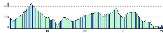
Elevation Profile