Shropshire Hills Walks
This fabulous AONB includes some of the walking highlights of England. Favourites include the climb to the iconic Wrekin and the wonderful Long Mynd.
Use the links to view full route information including elevation profiles, interactive maps and GPS downloads.
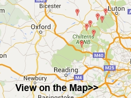
You can also view an overview map of all the routes in the using the Shropshire Hills Walk Map>>
*New* - Walks and Cycle Routes Near Me Map - Waymarked Routes and Mountain Bike Trails>>
| Route Name | Photo | Distance | Description |
| Adstone Hill | 5 miles (8.1 km) | This waymarked circular walk climbs to Adstone Hill on the Long Mynd near Ratlinghope in the Shropshire Hills. View Full Details>> | |
| Benthall Hall | 3.3 miles (5.3 km) | This circular walk near Ironbridge visits the Shropshire village of Benthall and the historic Benthall Hall. View Full Details>> | |
| Brown Clee Hill | 5.6 miles (9 km) | This walk climbs to Brown Clee Hill from the village of Burwarton. The circular route runs for about 6 miles with woodland trails, tarns and fine views from the high points.
The walk starts in Burwarton just to the east of the hill. From the village you can follow public footpaths west through Burwarton Park. On the way you'll pass pockets of woodland and the pretty Boyne Water. Just after passing the little lake you turn north west and link up with the Shropshire Way. Continue north along the waymarked path and it will take you toward Brown Clee Hill. Another public footpath branches off to the north east to take you up to the 540 metres (1,770 ft) summit of the hill where there is a Wireless Station and the Abdon Burf toposcope. This details some of the landmarks that you can see from this splendid, elevated position. You can take in far ranging views over the Shropshire Hills and into Wales from here. After taking in the views the route then descends to the east through Stanbroughs Wood. You then turn south to follow a bridleway back into Burwarton. View Full Details>> | |
| Caer Caradoc | 8.7 miles (14 km) | Climb to the 1500 ft (459 m) summit of this distinctive hill in the Shropshire Hills AONB. The circular walk starts at Church Stretton, near the train station, and takes you to the Caer Caradoc summit where you will find an ancient hill fort. There are fabulous views of The Wrekin, Long Mynd, Carding Mill Valley, Wenlock Edge, the hills of North Wales and the Brecon Beacons. The walk then descends towards Comley and continues to the pretty village of Cardington. From here you return to Church Stretton via Willstone Hill, passing Hope Bowdler Hill on the way. View Full Details>> | |
| Carding Mill Valley | 3.1 miles (5 km) | Visit a lovely reservoir and waterfall on this short walk in the Shropshire Hills AONB. The walk starts at the National Trust's Carding Mill Valley visitor centre and car park in Church Stretton. You begin by following a pretty stream uphill on a good stony path before bearing left on New Pool Hollow to visit the pretty reservoir. You'll pass mill pools and the 2500 year old Bodbury Ring hill fort on the way. The walk then continues uphill to Lightspot Hollow where you will find a waterfall in a beautiful V-shaped valley lined with bilberry, bracken and heather. You can look out for trout in the pools and stonechats, buzzards and red kites in the air. If you'd like to continue your walk you could head to the high point of the Long Mynd at Pole Bank. You could also climb the nearby Caer Caradoc for more fabulous views. The Shropshire Way and the Jack Mytton Way also pass through the area so you could pick these up easily too. View Full Details>> | |
| Church Stretton | 6.2 miles (10 km) | This attractive market town is a great place for exploring the Shropshire Hills Area of Outstanding Natural Beauty. It is located close to the lovely Carding Mill Valley and Long Mynd with various long distance trails also running through the area. The town was nicknamed Little Switzerland in the late Victorian and Edwardian period because of its landscape. The local geology includes some of the oldest rocks in England. This walk takes starts in the town near to the train station which is on the Welsh Marches line. The route then heads north west along a section of the Jack Mytton Way to Carding Mill Valley. View Full Details>> | |
| Clee Hills | 11.8 miles (19 km) | Visit Titterstone Clee Hill and Brown Clee Hill on this challenging walk in the Shropshire Hills AONB. Titterstone Clee stands at a height of 1,749 feet (533 m) while Brown Clee at 1,772 feet (540 m), is the highest peak in Shropshire. The views from the hills are truly wonderful with the Welsh Mountains of Snowdonia, Cadair Idris, the Brecon Beacons, and the Black Mountains visible.
There are fine views across the Shropshire Hills AONB including Long Mynd, Caer Caradoc and Stiperstones are also marvellous. To the south are the Malvern Hills and the Cotswolds, and to the east are the Clent Hills, Turner's Hill, and Barr Beacon. To the north is Cannock Chase and the Peak District including The Roaches and Winter Hill. This walk starts at the car park at Titterstone Clee Hill and follows the Shropshire Way 5 miles north to Brown Clee Hill. Look out for a variety of wildlife including rabbits, adders, peregrine, kestrel, skylark, Eurasian curlew and barn owl often scene on the hills. If you'd like to extend this walk you could start it from the nearby town of Ludlow and follow the Shropshire Way to Titterstone Hill. View Full Details>> | |
| Clun Castle | 8.4 miles (13.5 km) | This circular walk takes you through the countryside to the west of the small Shropshire town of Clun. On the way you'll visit the historic Clun Castle and the hamlet of Whitcott Keysett. There's also fine views of the Shropshire countryside and the Welsh Hills to enjoy. The walk makes use of two of the waymarked long distance trails that run through the area. You'll follow sections of the Shropshire Way ánd Offa's Dyke Path on the 9 mile route which includes some moderate hill climbs. View Full Details>> | |
| Coalbrookdale | 3.3 miles (5.3 km) | A circular walk from the village of Coalbrookdale exploring Shropshire's wonderful Ironbridge Gorge. View Full Details>> | |
| Corndon Hill | 2.5 miles (4 km) | Climb to this prominent hill in Powys and enjoy wonderful views over the Long Mynd and Stiperstones on this lovely walk on the Wales-England border. You can start the walk from a parking area just north of the hill, near the Mitchell's Fold stone circle. From here it is a short walk to the hill summit which stands at a height of 1,683 ft. The view from here is first class with the Shropshire Hills and Welsh Mountains stretching out in front of you for miles. On a clear day the Clee Hills, Severn Valley, Clwydian Hills, Cheshire Plain, Cadair Idris, the Rhinogs and the Black Mountains are all in focus. After taking in the view you can return the same way or turn it into a longer circular walk by descending south east and then south from the summit. The footpath then loops round to Lan Fawr near Priest Weston before returning to the car park. The walk to Mitchell's Fold Stone Circle starts from the same car park so you can easily visit the fascinating Bronze Age stones at the same time. Corndon Hill is located just a few miles west of the wonderful Stiperstones Nature Reserve. It's a great place to continue your walking with its craggy rock outcrops, gorgeous heather heathland and more wonderful views from the elevated position. The long distance Shropshire Way also runs nearby and is another great way to explore this beautiful area on foot. Also of interest is the Bishop's Castle Ring long distance footpath. It passes just to the west of the hill and will take you on a tour of the countryside and hills surrounding the Shropshire market town of Bishop's Castle. View Full Details>> | |
| Corvedale Three Castles | 11.2 miles (18 km) | This circular walk explores the valley of the River Corve around the village of Munslow, Shropshire. View Full Details>> | |
| Hope Bowdler | 2.5 miles (4 km) | This walk climbs to Hope Bowdler Hill from the Shropshire village of the same name. It's a moderate climb, running for about 1.5 miles along a decent footpath. View Full Details>> | |
| Hopton Castle | 5.6 miles (9 km) | This walk visits the Shropshire village of Hopton Castle where you can explore the ancient ruins of the mediaeval castle. It then goes on to follow a long distance waymarked footpath to the nearby Clun Castle. View Full Details>> | |
| Little Stretton | 10.4 miles (16.8 km) | The village of Little Stretton sits in an enviable position in the Shropshire Hills. The pretty village has a popular campsite and a decent local pub making it a popular start point for walking in this beautiful area. View Full Details>> | |
| Long Mynd | 5.6 miles (9 km) | This circular walk takes you to Pole Bank, the highest point on the Long Mynd in the Shropshire Hills AONB. Much of this beautiful area is owned and managed by the National Trust so there are good footpaths to follow to the 516m (1,693 ft) summit. The walk starts at the National Trust's Carding Mill Valley visitor centre and car park in Church Stretton. You begin by following a pretty stream uphill on a good stony path. You continue along Mott's Road passing Calf Ridge and Lightspot Hollow where there is the option to take a short detour to Lightspot Waterfall. At the top of the hill you head west along the ancient Portway, passing a Neolithic monument which was converted to a shooting box during the Victorian period. You soon come to the summit at Pole Bank where there are magnificent views of the Brecon Beacons, the Cambrian and Berwyn Mountains, Snowdonia and the Malverns. After taking in the views you descend passing the spring at Boiling Well and continuing through Townbrook Valley with its pretty brook and Victorian reservoir. A short woodland section then takes you to the finish point at the car park. The walk makes use of the Shropshire Way and the Jack Mytton Way so there is the option of continuing your walk along these long distance footpaths. You could also climb the nearby Caer Caradoc for more fabulous views. If you're looking for a shorter less strenuous walk you could visit the reservoir and waterfall on the Carding Mill Valley walk. View Full Details>> | |
| Mitchell's Fold Stone Circle | 2.4 miles (3.8 km) | Visit this fascinating Bronze Age stone circle and enjoy a hike across Stapeley Common and Stapeley Hill, on this lovely circular walk on the Wales - England border. It's a very beautiful and atmospheric area with the ancient stones surrounded by the stunning scenery of the Shropshire Hills AONB. You can start the walk from the parking area near the stones and cross the dry heathland to the site. The site originally consisted of 30 stones, of which 15 now remain. The surviving stones range in height from just 10 inches to 6 feet 3 inches (1.91 metres), standing in an ellipse 89 feet by 82 feet (27 metres by 25 metres). After exploring the site you can continue your walk by climbing to Stapeley Hill. Along the way there are fabulous views over the surrounding hills and countryside from the high points. The climb to Corndon Hill starts from the same location. You can follow tracks south to climb the hill which straddles the border with Wales. It's a great viewpoint with stunning views across the Welsh Mountains and Shropshire Hills. The long distance Bishop's Castle Ring also passes the stone circle. You can pick it up to explore the area surrounding the market town which lies just to the south. View Full Details>> | |
| Much Wenlock | 5.9 miles (9.5 km) | A circular walk around the Shropshire town of Much Wenlock, visiting the Wenlock Priory before exploring the surrounding countryside. There's nice views of the Shropshire hills including the famous Wrekin. Starting in the centre of the town the walk picks up the Shropshire Way long distance trail and follows it to the nearby Wenlock Priory. The fascinating site includes the atmospheric ruins of the 12th century St Milburga's Priory and some fine topiary in the surrounding grounds. It is run by English Heritage who charge a reasonable fee for entry. This gives you access to the Norman Chapter House with its elaborate stone carvings and the cloister garden. Here you'll find a huge lavabo (water vessel) with 12th-century carvings and some attractive topiary. After exploring the priory the route then picks up public footpaths to take you east, towards Arlescott Farm. Here you can see the humps and hollows of the lost medieval village of Arlescott. The route then turns left to pick up a section of the Jack Mytton Way to Wyke Farm. Here you turn west and follow the trail along a country lane to Bradley Farm where you turn south to return to the town. View Full Details>> | |
| Pontesbury and Pontesford Hill | 3.4 miles (5.4 km) | This circular walk from the village of Pontesbury climbs to Earl's Hill and Pontesford Hill for lovely views over the Shropshire countryside. There's much to enjoy with woodland trails, an Iron Age Hillfort and a variety of flora and fauna in the nature reserve area. Look out for the pretty bluebells in the woodland area during the spring months. In the summer you can see orange tip butterflies fluttering around the many wildflowers. The walk starts off from the centre of Pontesbury and heads east to the wooded area just to the north of the hills. You then follow the trails south to Pontesford Hill and Earl's Hill, which stands at a height of 320m (1049ft). Here you'll find a triangulation pillar, far reaching views over the Shropshire Hills and an Iron Age Hillfort dating from 600BC. After taking in the views you descend south to pick up the Marches Way trail. You can then follow this back through the woods towards the village. View Full Details>> | |
| Ragleth Hill | 2.2 miles (3.5 km) | This walk climbs to Ragleth Hill above Church Stretton in the Shropshire Hills. It's a fairly steep climb but only about a 1.5 mile walk from the town centre. Though not as popular a climb as its neighbour of Caer Caradoc, the hill provides some truly excellent views. The walk starts from the train station in Church Stretton where you can pick up the Jack Mytton Way. This waymarked footpath will take you south toward Dryhill Farm before climbing to Ragleth Hill. The hill stands at a height of just under 400 metres, offering fine views over the town below and the surrounding countryside. If you look to the north you can see Caer Caradoc which offers an opportunity for extending your walking in the area. View Full Details>> | |
| Shifnal | 8.7 miles (14 km) | This walk from the town heads through the countryside to visit the historic town of Ironbridge on the River Severn. On the way there's an easy climb to a pleasant viewpoint located just to the south of the town. View Full Details>> | |
| Shropshire Way | 139.2 miles (224 km) | This walk takes you through some of the most beautiful countryside in Shropshire. You will visit Shrewsbury, Clun (with its ruined castle), Ludlow, Clee Hills, Wenlock Edge, Ironbridge and The Wrekin, where there are some truly spectacular views of this splendid county. The walk begins at Grindley Brook, near Whitchurch, and runs along a circuit to finish a Wem.
Walk Highlights include:
| |
| Stiperstones | 9.3 miles (15 km) | The area around this popular Shropshire Hill is fantastic for walking and cycling. This walk takes you to the 536 m (1,759 ft) Stiperstones summit where you can enjoy fabulous views over the surrounding area. The Stiperstones is a 6 mile/10km ridge covered with craggy rock outcrops and gorgeous heather heathland. The area is also a National Nature Reserve with a diverse range of flora and fauna. Look out for red grouse, Eurasian curlew, peregrine falcon and the rare ring ouzel as you make your way across the hills. This walk begins in Habberley taking you through woodland to the Stiperstones ridge. You head along the ridge passing the quartzite tors that Stiperstones is famous for. These include Shepherd's Rock, the Devil's Chair and Manstone Rock. Manstone is the highest at 536 metres (1,759 ft) and commands fabulous views over the Shropshire Hills, the Long Mynd and Wales. From here you return to Habberley on different tracks, passing through a series of wooded areas as you go. If you'd like to continue your climbing in the area then you could head to the nearby Caer Caradoc and the stunning Long Mynd. This route also makes use of the Shropshire Way so you could continue along this path to the Bog Mine Visitor Centre where you'll find historical information about the area and two circular walks. View Full Details>> | |
| Stokesay Castle | 3.2 miles (5.2 km) | A circular walk from the Shropshire town of Craven Arms to the historic Stokesay Castle. The route runs for just over 3 miles on a series of waymarked footpaths and passes the historic castle where you will need to pay an entrance fee to English Heritage to gain access. You can just follow the free public footpaths round the site though if you prefer. On the way there's river paths, fascinating history and fine views of the lovely countryside of the Shropshire Hills AONB. The walk starts from Craven Arms train station and follows the Shropshire Way south through the countryside to the castle. Here you will find a wonderful medieval manor house which dates all the way back to the 13th century. View Full Details>> | |
| The Wrekin | 5 miles (8 km) | This popular circular walk takes you to the summit of this iconic Shropshire Hill. You start at the car park at Lawrence Hill and follow good footpaths along the Shropshire Way to the 407 m (1,335 ft) summit. View Full Details>> | |
| Titterstone Clee Hill | 0.9 miles (1.5 km) | This short climb visits a fine viewpoint in the Clee Hills. The conveniently located public car park makes it a short but rewarding climb with some excellent views to enjoy from the hill summit. You can start the walk from the car park directly the below the hill. From here you can pick up a footpath which snakes up to the hill top passing a former quarry and radar station on the way. It's about a half mile walk to the top, so a mile there and back. The summit stands at a height of 533 metres (1,749 ft) making it the third highest in Shropshire, behind Brown Clee Hill and Stiperstones. View Full Details>> | |
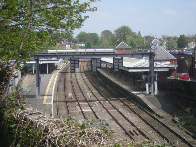
| Wellington | 6 miles (9.7 km) | This Shropshire based market town is considered the northern gateway to the Shropshire Hills AONB. As such it's a great place for walking with two of the area's highlights reachable on foot from the town. View Full Details>> | |
| Wenlock Edge | 19.3 miles (31 km) | Wenlock Edge runs from Craven Arms to Much Wenlock, in the Shropshire Hills AONB. This walk follows the 19 mi (31 km) limestone escarpment using the footpaths of the Shropshire Way and the Jack Mytton Way long distance routes. View Full Details>> | |
| Wenlock Edge Circular Walk | 5 miles (8 km) | This circular walk from Much Wenlock explores the eastern end of the beautiful Wenlock Edge. On the way you'll visit old quarries, follow peaceful woodland trails and enjoy fine views over the Shropshire Hills. In the summer months you can also enjoy lots of wildflowers and the smell of wild garlic. It's about a 5 mile route with some moderate climbing on the way. The walk starts from the National Trust car park just to the west of the town. From here you can pick up the Shropshire Way and follow it up through Blakeway Hollow to Blakeway Farm and Major's Leap. This noteworthy viewpoint is the spot from where a Royalist major is said to have jumped on horseback to escape pursuers during the Civil War. From here there are fine views of Caer Caradoc and the Long Mynd. The route then heads toward Presthope where you can see the old Knowle Quarry lime kilns. After passing the limestone quarries you descend back to the town. View Full Details>> | |
| Wistanstow and Flounders Folly | 4.8 miles (7.8 km) | The Shropshire based village of Wistanstow lies just to the north of Craven Arms in the beautiful Shropshire Hills. View Full Details>> |