Brecon Beacons Walks
With lakes, waterfalls, forests, country parks and numerous mountain climbs, the Brecon Beacons has something for walkers of all abilities. The area also includes the stunning Black Mountains with some of the best views in the country.
If you are looking for cycle routes please go to our Brecon Beacons Cycle Routes page.
Use the filter to show walks of a certain type such as woods, reservoirs, hills, long distance, country parks, canals and rivers.
In the spring walkers flock to the beautiful bluebell woods in the Brecon Beacons area. Click the 'Woodland' button below to see these.
Use the links to view full route information including elevation profiles, interactive maps and GPS downloads.
You can also view an overview map of all the routes in the using the Brecon Beacons Walk Map>>
*New* - Walks and Cycle Routes Near Me Map - Waymarked Routes and Mountain Bike Trails>>
| Filter: |
| Route Name | Photo | Distance | Description |
| Abergavenny Castle and River Usk Circular Walk | 1.2 miles (2 km) | This lovely circular walk takes you around the pretty meadows surrounding Abergavenny Castle. You'll also enjoy a riverside stroll along the River Usk and a visit to the delightful Linda Vista Gardens. The route starts near the tourist information centre in Abergavenny and takes you along the River Usk on a good path which is also open to cyclists. The path then heads to Linda Vista gardens, which is a well laid out public park with a variety of plants and flowers. You then pass the ruins of the 11th century Abergavenny Castle where there is a good museum detailing the history of the castle. Please note, only the first section of the route along the river is open to cyclists. If you'd like to continue your walking in the area you could pick up the Abergavenny Canal Walk along the Monmouthshire and Brecon Canal for more waterside footpaths. View Full Details>> | |
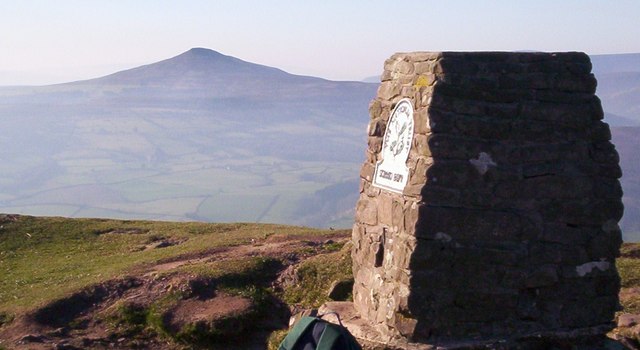
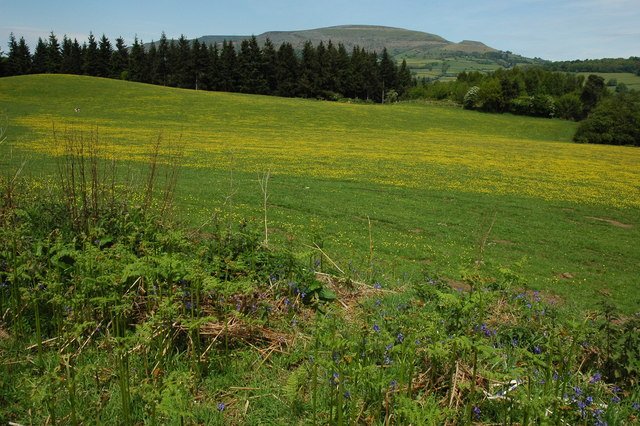
| Abergavenny Sugarloaf Walk | 7.1 miles (11.5 km) | This epic circular walk takes you to the summit of Sugarloaf Mountain from the town of Abergavenny. The distinctive hill is a prominent landmark in all directions and a very worthy climb. It's a challenging 7 mile hike with tremendous views for most of the way. Start the walk in the centre of Abergavenny, near to the bus station and priory. You can then follow roads north through the town to Cantref and Llywyndu. Country lanes here will lead you to the footpaths which will take you up to the Sugarloaf summit which stands at a height of 1,955 feet (596 metres). The far ranging views encompass the Usk Valley, Severn Estuary, the Cotswolds to the east, the Brecon Beacons including Pen y Fan and Corn Du to the west and the Bristol Channel to the south. After taking in the views you descend to the west and then south to the lovely Mynydd Llanwenarth ridge. After descending the ridge you then pick up the same country lanes and roads to take you back into the centre of Abergavenny. To continue your walking around the town you could try the climb to Skirrid Fawr which starts in Abergavenny. You could also pick up the long distance Brecon Beacons Way which runs through the area. For an alternative circular route try our Sugarloaf Mountain Walk which starts from the car park at the base of the hill. View Full Details>> | |
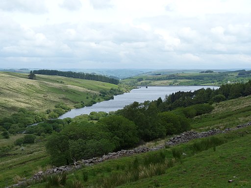
| Beacons Reservoir | 1.9 miles (3 km) | Enjoy a lovely stroll around this pretty reservoir in the fantastic Brecon Beacons. The nearby mountains of Pen Y Fan and Corn Du make a simply stunning backdrop to the walk. The walk also includes woodland sections on the western side of the reservoir and several waterside sections. If you're looking for a more challenging walk you could climb Pen Y Fan. The start point for this walk is near the northern end of the reservoir. This walk also makes use of the Brecon Beacons Way so you could pick this up and head deeper into this beautiful national park. View Full Details>> | |
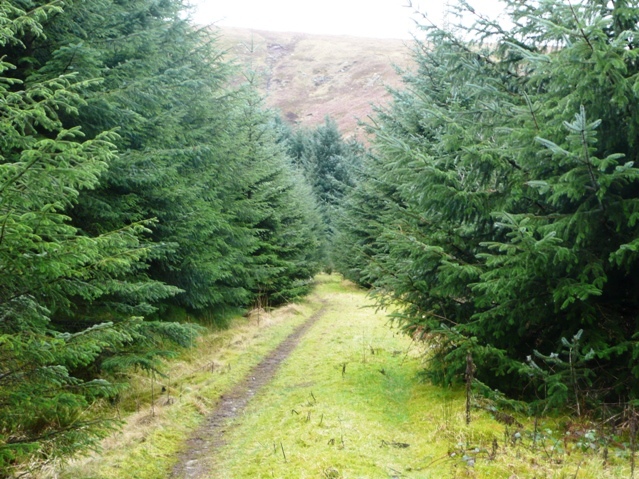
| Blaen y Glyn Waterfalls | 1.9 miles (3 km) | This walk visits a series of beautiful waterfalls on the River Caerfanell near Talybont Reservoir in the Brecon Beacons. The walk starts from the Forestry Comission's Upper Blaen-y-Glyn car park and takes you to Lower Blaen-y-Gly. You'll pass along woodland paths with several pretty falls to enjoy. There is also a picnic area and the opportunity to turn it into a circular walk using alternative woodland trails. If you'd like to extend your walk you could pick up the Taff Trail and follow it to the nearby Talybont Reservoir. The Fan Y Big and the Cribyn mountain climb also starts from the same point. View Full Details>> | |
| Blorenge | 7.5 miles (12 km) | This challenging walk takes you around this prominent hill in the southeastern corner of the Brecon Beacons National Park. The hill is located near Abergavenny and rises to a height of 561 m (1,841 ft). This popular walk starts at the car park next to Keeper's pond and follows footpaths across the hill before climbing to the summit. There are fabulous views of the Usk Valley, Sugarloaf Mountain and Skirrid Fawr. You'll also pass through the Punchbowl on the eastern side of the hill. This delightful area has a large pond and woodland which attracts a wide variety wildlife. If you're interested in more hill climbing in the area then Sugarloaf Mountain and Skirrid Fawr are also easily reachable from Abergavenny. View Full Details>> | |
| Brecon | 4.2 miles (6.7 km) | This circular walk from the town of Brecon takes you along the Monmouthshire and Brecon Canal and the River Usk. There's nice easy waterside footpaths with fine views of the countryside surrounding the town. The walk starts in Brecon town centre and heads to the canal basin. You can then follow the towpath east for about 2 miles before picking up the riverside path along the Usk. This will lead you back into the town. View Full Details>> | |
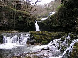
| Brecon Beacons Waterfall Walk | 11.1 miles (17.8 km) | A long circular walk visiting several of the National Park's wonderful waterfalls. The route visits the famous Four Waterfalls and the lovely Neath Waterfalls with nice woodland trails and fine views of the surrounding mountains to enjoy. Start the walk from the Gwaun Hepste car park near Ystradfellte. It's a good sized parking area which also includes a picnic area. From here you pick up the woodland trails heading south west to visit the first waterfall of Sgwd Uchaf Clyn Glyn. The paths continue south along the Afon Mellte to Sgwd Isaf Clun-Gwyn, the lower of the Clyn Glyn falls. Further south you will come to Sgwd yr Eira, probably the most photographed waterfall in the Brecon Beacons because you can actually walk behind the curtain of thundering water. The route then heads south west through the woodland to reach the village of Pontneddfechan. There's more beautiful waterfalls to see here as you head north from the village along the Afon Nedd Fechan and the Afon Pyrddin, upland tributaries of the River Neath. You'll pass the Sgwd Gwladus and Sgwd Ddwli falls as you make your way through this lovely section of Waterfall Country. The first is known as 'Lady's Falls' and are formed where the Afon Pyrddin drops 20 ft (6 m) over a lip of the 'Twelve Foot Sandstone'. The lady in question was one of the daughters of Brychan, the 5th-century King of Brycheinog. The sandstone tilts gently to the south so forcing the waters of the Pyrddin up against the foot of a high cliff of mudstone and over the left-hand side of the rock lip. After emerging from the woods, the final section crosses countryside to return to the Afon Mellte. From here it is a short walk back to the car park and the finish point of the route. View Full Details>> | |
| Brecon Beacons Way | 98.2 miles (158 km) | Follow the Beacons Way through the centre of the stunning Brecon Beacons National Park. The walk begins at Abergavenny and follows the trail through the park to Llangadog. On the way you will pass some of the most breathtaking scenery in the UK with marvellous views of Sugarloaf Mountain, Skirrid Fawr, Llanthony Priory, The Black Mountains, Talybont Reservoir, Llyn y Fan Fach, Table Mountain, Pen Cerrig Calch and Pen Y Fan - the highest peak in South Wales and southern Britain. View Full Details>> | |
| Brecon to Talybont Canal Walk | 7.1 miles (11.4 km) | This waterside walk takes you along the opening section of the Monmouthshire and Brecon Canal, from Brecon to the village of Talybont On Usk. The route runs for just over 7 miles on the flat canal towpath, passing a series of aqueducts, old bridges, marinas and weirs. The walk starts from the canal basin in Brecon and heads east towards the Brynich Aqueduct which carries the canal over the River Usk. The route turns south here, taking you to Storehouse Bridge where there's a marina and another aqueduct. The final section runs from Pencelli into Talybont-on-Usk. The small village has a shop and several pubs for refreshments after your walk. View Full Details>> | |
| Cambrian Way | 297.6 miles (479 km) | This epic long distance trail runs from Cardiff on the south coast of Wales to Conwy on the north coast. View Full Details>> | |
| Carreg Cennen Castle | 1.9 miles (3 km) | Enjoy a circular walk around this spectacularly positioned ruined castle in Carmarthenshire. The castle sits on an elevated limestone precipice with fabulous views over the lovely Brecon Beacons countryside. There are a series of good footpaths taking you around the grounds and an invigorating climb up to the castle itself. The castle includes a natural cave which leads deep into the hillside, six towers, a great twin-towered gatehouse and the fascinating King's Chamber dating from the 13th/14th century. The Brecon Beacons Way also runs past the castle so you can pick this up to continue your walking in the area. Carreg Cennen Castle is located about four miles south of Llandeilo on the western tip of the Brecon Beacons National Park. To continue your walking in the area head to Llandeilo and visit Dinefwr Park. View Full Details>> | |
| Clydach Gorge | 8.7 miles (14 km) | This beautiful gorge in the Brecon Beacons includes a steep-sided valley down which the River Clydach flows to the River Usk. View Full Details>> | |
| Craig-y-Nos Country Park | 2.2 miles (3.6 km) | This delightful 40-acre Victorian garden is perfect for a peaceful stroll. There are well laid out walking paths taking you through woodlands, meadows, wide lawns and along the River Tawe which runs through the park. Craig-y-Nos Country Park is located in the Brecon Beacons National Park so the surrounding scenery is spectacular. Within the park you will find the historic Craig-y-nos Castle surrounded by beautiful landscaped gardens and two pretty lakes which attract a wide variety of wildlife. There is also a visitor centre and tea room with benches and picnic areas. View Full Details>> | |
| Craig Cerrig-Gleisiad a Fan Frynych | 3.1 miles (5 km) | Enjoy a walk through this spectacular glacial National Nature Reserve and climb to the summit of Fan Frynych on this challenging walk in the Brecon Beacons. The reserve can be easily accessed from a lay-by on the A470 from which the walk starts. Soon you will be exploring this wonderful natural amphitheatre with imposing craggy cliffs created during the Ice Age, 20000 years ago. The reserve contains rare arctic-alpine plants such as purple saxifrage and mossy saxifrage. There is also an abundance of wildlife to look out for including Peregrine falcons, merlin, red kite and a variety of butterflies. The area also contains woodland, streams and an Iron Age Hillfort. From the 629 m (2,064 ft) summit of Fan Frynych there are splendid views over the national park. The Brecon Beacons Way also passes the reserve so you could pick this up to continue your walk. View Full Details>> | |
| Cray Reservoir | 1.2 miles (2 km) | Enjoy a walk along this peaceful reservoir in the Brecon Beacons. The lake is surrounded by some lovely lush countryside and woodland. It's purpose is to supply water to the towns in the valley of the River Tawe and north Swansea, but it also makes for a nice easy walk. You can park at the car park just off the A4067 Swansea Sennybridge road, on the eastern side of the water. Then pick up the footpaths heading north up to the dam with great views across the water and pretty waterfalls to see on the way. You can extend the walk by continuing north along the riverside paths of the River Crai which feeds the reservoir. View Full Details>> | |
| Crickhowell Canal Walk | 5.6 miles (9 km) | A waterside walk along the Monmouthshire and Brecon Canal from Crickhowell to Llangynidr. The route runs for about 5.5 miles along the towpath with a shady section at the start before nice views over the surrounding hills and countryside as you approach Llangynidr. The walk starts in the centre of Crickhowell and crosses the River Usk before following country lanes to the canal at the village of Llangattock. You then head north west past Dandy and Glanusk Park on a tree lined section of the canal. The route finishes at the village of Llangynidr where there's five locks and an aqueduct nearby. There's also a Grade I listed stone bridge over the River Usk which dates from 1700. View Full Details>> | |
| Crickhowell River Walk | 3.1 miles (5 km) | A short stroll along the River Usk in the town of Crickhowell (Crug Hywel) in the Brecon Beacons. The walk starts next to Crickhowell Castle also known as 'Alisby's Castle'. The ruined castle dates from the 12th century and is now Grade I listed. From here it is a short walk down to the river where you will pass the impressive Crickhowell bridge. The 18th-century bridge is claimed to be the longest stone bridge in Wales at over 128 metres (420 ft). Turn west at the bridge and you can follow a footpath along the northern side of the river for just over a mile. You have the option of continuing west to Glanusk Park where there is a nice permissive path to follow through the large estate. View Full Details>> | |
| Cynghordy Viaduct | 2.2 miles (3.5 km) | This circular walk visit the impressive Cynghordy Viaduct in Carmarthenshire. The route runs for just over 2 miles with some small climbs and fine views of the surrounding hills and countryside. The walk starts from Cynghordy railway station on the Heart of Wales Line about 46 miles north east of Swansea. View Full Details>> | |
| Dinefwr Park | 4 miles (6.5 km) | Explore the 12th-century Welsh castle, the historic house, the 18th-century landscaped park and the medieval deer park in this large park in Llandeilo. View Full Details>> | |
| Dragons Back | 7.1 miles (11.5 km) | Climb the Dragons Back on this challenging circular walk in the Black Mountains, Wales. The route runs for just over 7 miles and includes a visit to the highest point of the Black Mountains at Waun Fach. The views along the ridge are breathtaking in all directions. The walk starts from the parking area near Pengenffordd. Head north from here toward the village where you can pick up a trail heading east to Castell Dinas. This Iron Age hillfort has the highest castle in England and Wales. A Norman castle was built here in the 11th century. What remains now are crumbling walls mainly covered with earth and the outlines of ditches and ramparts from the original Iron Age fortifications, commanding extensive views up into the Black Mountains and over Talgarth towards Brecon. After exploring the fort the route continues east to Y Grib and Pen Y Manllwyn. Here you turn south to Waun Fach which stands at a height of 811 m (2,661 ft). From here there are views over the Brecon Beacons including Rhos Fawr and the Radnor Forest. You may also see some wild ponies wandering around the area. The walk then descends to the south west toward Pen Trumau. Soon after you turn west along Rhiw Trumau and Cwmmfforest. The route then returns to the car park. You can enjoy well earned refreshments at the Castle Inn in Pengenffordd after your exercise. View Full Details>> | |
| Elidir Trail and Sgwd Gwladus Waterfall | 5 miles (8 km) | This walk in Pontneddfechan visits Sgwd Gwladus in Wales' beautiful waterfall country. The route runs for about 5 miles, following Nedd Fechan past a series of lovely waterfalls in a peaceful wooded valley. The walk starts in the village of Pontneddfechan where you can pick up the footpath along the Nedd Fechan and follow it north to Sgwd Gwladus. Also known as The Lady Fall these elegant falls drop from a height of about 20 feet. The falls are named after Gwladus, one of the daughters of the 5th century prince Brychan. It's a lovely spot with the rushing falls and a series of stepping stones over the River Pyrddin. The route then continues to visit Scwd Einion Gam and Scwd Ddwli before turning round at the bridge to the north of the latter falls. You then return to the village on the same paths. View Full Details>> | |
| Fan Gyhirych | 1.2 miles (2 km) | This walk climbs to the 2379 feet (or 725 m) summit of Fan Gyhirych mountain in the Fforest Fawr section of the Brecon Beacons National Park. View Full Details>> | |
| Fan Y Big and the Cribyn | 7.5 miles (12 km) | This walk makes use of the Brecon Beacons Way to take you to Fan Y Big and Cribyn mountains from the Blaen y Glyn Waterfalls. You start off in the Blaen y Glyn car park and climb to the 719 m (2,359 ft) summit of Fan Y Big. This section passes along the spectacular Craig Fan Ddu with wonderful views towards Fan Y Big. From the Fan Y Big summit you continue west along Craig Cwm Cymwyn to the 795 m (2,608 ft) summit of Cribyn. You can extend the walk by continuing west to the summit of Pen Y Fan. It's a spectacularly beautiful area with wide ranging views across the national park. Also look out for a wide variety of wildlife which includes red kites, sky larks, meadow pipits, peregrines and kestrels. View Full Details>> | |
| Four Waterfalls Walk | 5 miles (8 km) | This is a specatacular walk visiting four beautiful waterfalls near Ystradfellte in the Brecon Beacons. It is one of the best waterfall walks in Britain with delightful woodland gorges, riverside trails along the Afon Mellte and a series of roaring waterfalls. The popular trail starts at the Gwaun Hepste car park just south east of Ystradfellte. It's a good sized parking area which also includes a picnic area. From here you can pick up the trails to the Sgwd Clun-Gwyn, Sgwd Isaf Clun-Gwyn, Sgwd y Pannwr and Sgwd-yr-Eira waterfalls. Sgwd Isaf Clun-gwyn is a particularly impressive and powerful waterfall which will take your breath away. Sgwd yr Eira, is also noteworthy as probably the most photographed waterfall in the Brecon Beacons. You can actually walk behind the curtain of thundering water which is a great experience. There are also many other smaller waterfalls dotted around this area known as Waterfall Country. There are some challenging sections on the walk but the footpaths are well surfaced and maintained. View Full Details>> | |
| Garwnant | 8.1 miles (13 km) | This walk visits the Coed Taf Fawr and a series reservoirs near Merthyr Tydfil. The visitor centre here is considered the southern gateway to the Brecon Beacons National Park. There are lots of good walking paths and mountain bike trails to try here. The walk starts from the car park and visitor centre located at the northern end of Llwyn-on Reservoir. From here you can pick up the waymarked Taff Trail andf follow it north along the river to Cantref Reservoir. The walk then continues north to visit the pretty Beacons Reservoir. View Full Details>> | |
| Grwyne Fawr Reservoir | 5 miles (8 km) | This is a lovely waterside walk along the Grwyne Fawr to Grwyne Fawr Reservoir in the Brecon Beacons. You can start your walk from the Mynydd Du car park and follow the trails north to the reservoir. The rushing waters and the beautiful scenery of the Vale of Grwyney are a real delight. The route climbs to a height of over 1800ft so is quite challenging. You are rewarded with splendid views over the surrounding hillls of the Black Mountains. View Full Details>> | |
| Hay Bluff | 0.9 miles (1.5 km) | This is a popular climb to Hay Bluff hill in the Black Mountains. The hill straddles the border of Wales and England. Most of the area lies within Powys with the eastern flanks in Herefordshire. From the summit there are wonderful views over the Wye Valley and the Welsh Mountains. This walk starts from the Hay Bluff car park located just half a mile north west of the hill. However, you could also start the walk from Hay on Wye. Just follow the Offa's Dyke Path south from the town centre for about three miles and you will reach the hill. The path passes Cusop and Tack Wood before arriving at the car park and Stone Circle at the foot of the climb. The route to the 677 m (2,221 ft) passes Ffynnon y Parc on a good path. You can further explore the area as the entire hill is designated as open country so walkers have the freedom to roam at will. View Full Details>> | |
| Hay on Wye | 9.9 miles (16 km) | This circuit around Hay on Wye takes you into the Brecon Beacons National Park on the Offa's Dyke Path. It then climbs to the magnificent viewpoint of Hay Bluff, a few miles to the south of the town. The walk starts from Hay Castle which was originally constructed in the 11th century. In the 17th century a Jacobean mansion house was built alongside the medieval keep and the property became a private home. From here you can pick up the waymarked Offa's Dyke Path and head south towards Tack Wood. The path climbs to Hay Bluff which lies in the Black Mountains on the border of Wales and England. From the 677 m (2,221 ft) summit there are fabulous views over the Black Mountains, Brecon Beacons and the English county of Herefordshire. After taking in the views, the path then loops round before descending back towards Tack Wood. Here you can continue along the nice country lane or follow footpaths towards Cusop Dingle and follow the Dulas Brook back to the town. Here you can enjoy a stroll around the pleasant streets and visit one of the many bookshops which the town is famous for. If you are visiting in late May to June you can enjoy the Hay Festival. The popular literary festival draws about 80,000 visitors to see and hear big literary names from all over the world. View Full Details>> | |
| Henrhyd Falls | 3.1 miles (5 km) | Visit the spectacular Henrhyd Falls and the rushing Nant Llech River on this splendid walk in the Brecon Beacons National Park. The falls are the highest in South Wales at 90 feet (27m). There's the additional bonus of being able to walk around the back of the falls and see it from a completely different perspective. The walk starts at the National Trust car park at Dol Henrhyd, Coelbren (postcode:SA10 9PH). From here you follow a footpath heading west to the falls and then along the Nant Llech River towards Ynyswen. On the way you will pass through a lovely wooded valley where you will see another small waterfall and a disused watermill before coming to the River Tawe. Return to the start point on the same path. The final scene of the film The Dark Knight Rises was filmed at Henrhyd Falls, where it doubled as the entrance for the Batcave. This has drawn extra visitors to the site so it can be busy at peak times in the summer holidays. View Full Details>> | |
| Llandeilo | 9 miles (14.5 km) | This circular walk takes you through the countryside surrounding the Carmarthenshire town of Llandeilo. It makes use of two of the waymarked footpaths which run through the area. The walk starts in the town near to the train station. From here you head east to cross the River Towy before heading south to Tregeyb Wood. This area is also a nature reserve with some nice woodland trails. Ancient woodland (predominantly oak and ash), grassland and new native woodland are the prominent features. The route then follows countryside paths to Carreg Cennen Castle. View Full Details>> | |
| Llandovery | 3.7 miles (6 km) | This market town in the Cambrian Mountains has some nice riverside walks along the River Towy and River Bran to try. This circular walk takes you along the river before exploring the woodland and countryside to the south of the town. View Full Details>> | |
| Llangorse Lake | 3.7 miles (6 km) | Follow good footpaths around the western side of this beautiful lake in the Brecon Beacons National Park. Llangorse is the largest natural lake in Wales and a must see of the region. It is located near to the town of Brecon and the village of Llangors. The walk starts at the northern end of the lake where parking is available. You then follow waymarked public footpaths through the pretty countryside to a lakeside viewpoint at Llangasty. Here you'll also find a 19th century lakeside church. The lake is surrounded by some lovely scenery with green hills, fields and meadows. The area is also a nature reserve so look out for a variety of wildlife on your walk. These include otters, water voles, coots, swallows, swifts and geese. Also of interest is the Crannog - an ancient man-made island of oak, willow and hazel wood. If you would like to continue your walking in the area then the Taff Trail is located nearby. You can pick it up in Talybont On Usk where you can also enjoy a riverside walk along the Usk Valley Walk. Running just to the south east of the site is the Brecon Beacons Way. The epic long distance trail is a great way of exploring the national park on foot. View Full Details>> | |
| Llanthony Priory Circular Walk | 3.1 miles (5 km) | This walk visits the historic Llanthony Priory in the Vale of Ewyas, Brecon Beacons. The former Augustinian priory dates back to 1100 and is a Grade I listed building. The picturesque ruins are now under the care of Cadw and entrance is free to the public. The Brecon Beacons Way long distance trail runs past the abbey so this route uses part of the waymarked path to create a circular walk around the abbey. You can start from the car park next to the priory and then follow footpaths east to pick up the long distance trail. Follow the trail south east and the path will join with the Offa's Dyke Path. The National Trail runs just to the east of the priory and is a great way of exploring this area on the English-Welsh border. This route heads west along public footpaths to Maes-y-Beran before turning north west to return to the car park. View Full Details>> | |
| Llyn Cwm Llwch | 3.1 miles (5 km) | Llyn Cwm Llwch is the best preserved glacial lake in South Wales. There are many legends about the lake and the fairies that live on an invisible island in the lake. This walk takes you through the Cwm Llwch valley to this popular beauty spot in the Brecon Beacons National Park. The walk starts at the car park near the lake and involves a steep climb along the Cwm Llwch river to the beautiful lake. The surrounding scenery of the Brecon mountains is simply stunning. View Full Details>> | |
| Llyn y Fan Fach | 5 miles (8 km) | This is a super waterside walk through a particularly beautiful section of the Brecon Beacons. The walk starts at a parking area north of the lake and takes you along the Afon Sawddle to the lovely Llyn y Fan Fach. It's a good track that climbs steadily towards the lake where you will first reach the Dam before climbing to Bannau Sir Gaer on the western side of the water. From here there a truly wonderful views over the lake and surrounding mountains. The lake is a great place for bird spotting. Look out for red kite, common buzzard, kestrel, carrion crow, common raven and skylark as you make your way around the water. The Brecon Beacons Way runs past the lake so you could pick this up and head east to Llyn y Fan Fawr to continue your walk. Heading north would take you to Llanddeusant with wonderful views over the Black Mountains. View Full Details>> | |
| Llyn Y Fan Fawr | 9 miles (14.5 km) | This challenging circular walk visits Llyn Y Fan Fawr and Llyn Y Fan Fach in the Brecon Beacons. These two beautiful, isolated lakes are located close to each other on the northern margin of the Black Mountain in Carmarthenshire. It's a very peaceful and remote area with stunning scenery for the duration of the route. The walk runs for a distance of about 9 miles with some challenging climbs to the mountains which rise up above the lakes. Start the walk from the Llyn Y Fan Fach car park which lies about a mile north of the lake. From here you can pick up a track heading south to the lake and the dam. The trail then climbs around the western and southern side of the lake to Picws Du and then east to Fan Foel and Fan Brycheiniog. This hill stands at a height of 802 metres and commands breathtaking views over the area. The path then descends from Fan Brycheinog to Llyn Y Fan Fawr where you follow a trail along the eastern side of the water. You then climb to a series of hills on the northern side of the range. You'll pass Pant Y Bwlch and enjoy views of the River Sychlwch on this section. The river leads into Llyn Y Fan Fach where you can follow the same trail north to return to the car park. View Full Details>> | |
| Lord Hereford's Knob (Twmpa) | 1.2 miles (2 km) | This is a short climb to Lord Hereford's Knob or Twmpa in the Black Mountains. The scenery is stunning with magnificent views over the Brecon Beacons National Park on one side and the Herefordshire countryside on the other. You can park at the Gospel Pass car park about 1 mile to the east of the hill. From here you can pick up the footpath to the 690 m (2,260 ft) summit. View Full Details>> | |
| Merthyr Tydfil | 2.6 miles (4.2 km) | The town of Merthyr Tydfil is nicely positioned on the edge of the Brecon Beacons and next to the River Taff. There's some good walking trails along the river and up to the series of reservoirs and forests which lie just to the north of the town. This circular walk visits some of the highlights of the area including Cyfarthfa Castle and the River Taff. The walk starts at the Grade I listed Cyfarthfa Castle in the town. The castle is surrounded by attractive gardens, woodland paths, wide lawns and a pretty lake. There's also fine views of the town and the surrounding hills from the castle's elevated position. Follow paths around the lake and you can cross the Taf Fechan and the River Taff to join with the Taff Trail. View Full Details>> | |
| Monmouthshire and Brecon Canal | 37.3 miles (60 km) | Follow the Monmouthshire and Brecon Canal from Brecon to Newport on this super waterside walking and cycling route. Walkers can enjoy the whole route along canal towpaths while cyclists can follow National Cycle Network routes 4, 47 and 49 from Newport to Pontypool. The cycle path is wide and well surfaced so it's a lovely, safe ride. The cycle section runs for about 12 miles. The whole route runs from Brecon to Newport passing through the beautiful and dramatic scenery of the Brecon Beacons National Park. The first section runs from Brecon to Talybont-On-Usk via Pencelli. It's a 6.5 mile walk with views of the River Usk and the pretty Brynich Lock. The canal continues to the delightful Llangynidr locks and then on to Crickhowell and Abergavenny. There's an opportunity here to visit Abergavenny Castle Meadows and Linda Vista Gardens with a small detour from the canal. The next section runs from Abergavenny to Pontypool, passing the noteworthy Goytre Wharf, with its historic limekilns, boat hire, informative heritage centre and on site cafe. The final section runs from Pontypool to Newport via Cwmbran. This section is open to cyclists. On the way you'll pass the noteworthy Fourteen Locks. The impressive flight of locks date from the 18th century and includes an excellent visitor centre with a wealth of information about the area. The route finishes shortly after in Newport near the castle. View Full Details>> | |
| Mynydd Du Forest | 8.1 miles (13 km) | This large area of woodland in the Black Mountains has miles of forest tracks suitable for walking and mountain biking. The waters of the Grwyne Fawr run through the woods so there is the option of a waterside walk to the nearby Grwyne Fawr Reservoir along the river. You can start your exercise from the Mynydd Du car park at the northern end of the woods, a few miles west of the splendid Llanthony Priory. It's situated in a nice spot at the end of a country lane just next to the river. From here you can pick up the forest trails through the western side of the woods before crossing the river at Pont Cadgwan and returning on the eastern side of the river. There's lots of attractive trees and plants and some steep climbs with great views of the surrounding hills. The riverside sections are lovely too with lots of pretty waterfalls to enjoy. View Full Details>> | |
| Mynydd Illtud Common | 1.9 miles (3 km) | Starting at the Brecon Beacons Visitor Centre, enjoy a stroll across the pretty Mynydd Illtud Common on this easy circular walk. From the common there are great views towards Pen Y Fan and Corn Du, the Black Mountains and the river Usk. It's a good spot for wildlife too - look out for red kites, larks and butterflies. View Full Details>> | |
| Neath Waterfalls Walk | 9.3 miles (15 km) | This long circular walk explores the rivers and waterfalls in the Vale of Neath, also known as 'Waterfall Country'. It's a spectacularly beautiful area with a huge number of waterfalls to see. The falls are of varying size with some of them allowing you to walk behind them for a really special experience. This route runs for about 9 miles on generally good footpaths with some moderate climbing as you cross the countrsyide between the two woodland gorges. The route starts in the village of Pontneddfechan and heads north along the Afon Nedd Fechan and the Afon Pyrddin where there's a lovely wooded gorge and the Sgwd Gwladus falls to see. The route then heads north east out of the gorge into open countryside towards Ystradfellte. Here you can pick up the popular Four Waterfalls Walk to visit Sgwd Clun-Gwyn, Sgwd Isaf Clun-Gwyn, Sgwd y Pannwr and Sgwd-yr-Eira waterfalls. The route then follows more woodland trails through the forest to the east of the village before returning to Pontneddfechan. View Full Details>> | |
| Pen y Crug | 2.5 miles (4 km) | This walk climbs to the ancient hill fort and viewpoint on Pen-y-crug hill in Powys in the Brecon Beacons. View Full Details>> | |
| Pen Y Fan | 5 miles (8 km) | Climb the highest peak in South Wales and southern Britain on this stunning walk in the Brecon Beacons National Park. This is a challenging climb to the 2906 feet (886m) summit but the footpaths are generally very good for most of the walk. You start at the car park at Storey Arms about 10 miles north of Merthyr Tydfil. There is an alternative car park at Pont ar Daf just to the south if you prefer. The first stage passes through woodland and crosses Blaen Taf Fawr before ascending toward Bwlch Duwynt. You continue to Corn Du where there are fabulous views of the Neuadd Valley, Cantref Reservoir, Beacons Reservoir and Llwyn-on Reservoir. Shortly after you reach the summit of Pen Y Fan where you will find a former Bronze Age burial chamber. The views are fantastic with Sugar Loaf, the Bristol Channel , Carmarthen Bay, Swansea Bay, the Gower Peninsula, the Black Mountains, the Cambrian Mountains and Exmoor all visible on a clear day. From the summit you descend to Corn Du and then on to the heather covered Y Gyrn. You soon come to a woodland area and the finish point at the car park. View Full Details>> | |
| Pen y Fan Horseshoe Walk | 7.8 miles (12.6 km) | This fantastic horseshoe ridge walk visits Pen Y Fan, Corn Du and the Cribyn in the Brecon Beacons National Park. It's a challenging hike but you will be rewarded with some simply stunning views over the surrounding peaks and reservoirs. The walk starts from the car park in Taf Fechan Forest and heads north to the beautiful Lower Neuadd Reservoir. You then climb west onto the Craig Fan Ddu ridge and head north with fantastic views toward Pen y Fan and Corn Du. The route climbs to the summit of Corn Du at 873 m (2,864 ft). Here you will find a well structured Bronze Age cairn and views to the Black Mountain range and Fforest Fawr. You continue a short distance to the 886 m (2,907 ft) summit of Pen Y Fan which is the highest peak in south Wales. There's more panoramic views here to the Bristol Channel, Carmarthen Bay, Swansea Bay, the Gower Peninsula, the Black Mountains, the Cambrian Mountains, Exmoor and the Clee Hills in South Shropshire can be seen. After taking in the views the route descends along Craig Cwm Sere to the Cribyn, standing at a height of 795 m (2,608 ft). The impressive views include Mynydd Epynt, the town of Brecon and the Cambrian mountains beyond. Look out for mountain birds including peregrine falcons, common buzzards and the red kite in this area. You continue the descent along Craig Cwm Cynwyn toward Bwlch Y Fan and Fan-y-Big. The final section descends past Tor Glas and the Upper and Lower Neuadd Reservoirs to the car park. View Full Details>> | |
| Pontsticill Reservoir | 6.5 miles (10.5 km) | This circular walk takes you around the beautiful Pontsticill Reservoir in the Brecon Beacons National Park. The reservoir is located a few miles north of Merthyr Tydfil on the Taff Trail. You can catch the splendid Brecon Mountain Railway to Pontsticill station next to the reservoir. The railway runs from Pant near Merthyr Tydfil along the full length of the Pontsticill Reservoir to Torpantau high in the Brecon Beacons. The walk starts near the Dam and Pontsticill station and heads along the Taff Trail through a woodland area on the western side of the reservoir. You return on the eastern side, climbing towards Cwm Criban for splendid views of Pontsticill and the surrounding countryside. You then descend towards the dam and the finish point. The route runs for just under 7 miles and includes a moderate climb on the way. View Full Details>> | |
| Radnor Forest Ride | 62.1 miles (100 km) | A long distance shared walking and cycle path that runs from Llanfair Waterdine on the English-Welsh border to the Brecon Beacons Visitor Centre. It will take you through the expansive area of the Radnor Forest located to the north of the Black Mountains and to the east of the Cambrian Mountains. The forest is noted for its photogenic geology and a wide variety of interesting flora and fauna. The path follows a series of bridleways and minor country roads through some wonderful scenery including the beautiful Wye Valley and the spectacular Brecon Beacons. View Full Details>> | |
| Sgwd Yr Eira Walk | 7 miles (11.2 km) | This walk visits the beautiful Sgwd Yr Eira waterfall from Pontneddfechan in the heart of Waterfall Country. It's about a 2.5 mile walk to the falls from the village, passing through woodland on a series of footpaths with some moderate climbs on the way. The falls are one of the most spectacular in the area, located on the Afon Hepste in a steep rocky ravine. You can even walk behind the waterfall for a wonderful view of the blanket of rushing water. The walk starts in the village and follows the Afon Mellte north east into the wooded gorge. You soon come to the Craig-y-Ddinas car park which is an alternative start point for the walk. Here you can branch of to the south and visit the lovely Afon Sychryd where there are two waterfalls to see. There's also the Dinas Rock, a high promontory of Carboniferous Limestone which rises between the Afon Mellte and the Afon Sychryd. The route continues along the river, passing footbridges and weirs before coming to Sgwd yr Eira. The name translates as 'fall of snow' and includes a footpath running behind the water. It's a wonderful sight and one of the highlights of the Brecon Beacons National Park. View Full Details>> | |
| Skirrid Fawr | 9 miles (14.5 km) | Climb this 486m (1594 feet) mountain in the Brecon Beacons on this challenging walk. Skirrid Fawr (or Ysgyryd Fawr) forms part of the Black Mountains range. The walk starts in Abergavenny, next to the tourist information centre and follows the Marches Way long distance trail to the summit. Here you will find the ruins of an iron–age hill fort and St Michael's medieval Roman Catholic church. There are splendid views across the Brecon Beacons, Black Mountains, Abergavenny and the surrounding countryside. The walk descends through woodland areas before rejoining the Marches Way and returning to Abergavenny. If you'd like to climb another black mountain then the iconic Sugarloaf is also near Abergavenny. The Brecon Beacons Way also runs through the area so you could pick this up to continue your walk. View Full Details>> | |
| Sugarloaf Mountain | 5 miles (8 km) | Climb to the summit of this iconic mountain on this challenging circular walk in Monmouthshire, Wales. Sugarloaf is part of the Black Mountains range and stands at a height of 1,955 feet (596 metres). The walk starts at the car park to the south of the summit near the town of Abergavenny. You head towards the lovely oak woodland of St Mary's Vale where you will pass pretty streams and a variety of woodland wildlife. You continue on to the summit where there are fabulous views of the Severn Estuary, the Cotswolds to the east, as far as the Brecon Beacons including Pen y Fan and Corn Du to the west and the Bristol Channel to the south. There are also great views over the nearby Usk River Valley and Abergavenny. On a clear day you could also see the Shropshire Hills and Somerset. You descend towards Mynydd Llanwenarth, passing ancient medieval ditches before returning to the finish point, back at the car park. If you'd like to continue your climbing in the area then the Skirrid Fawr walk also starts in Abergavenny. You could also pick up the splendid Brecon Beacons Way which runs through the area. To start the hike from the town see our alternative Abergavenny Sugarloaf Walk which starts from the bus station in the town centre and uses an alternative path to climb to the summit. View Full Details>> | |
| Table Mountain | 3.7 miles (6 km) | Enjoy wonderful views over the Brecon Beacons on this moderate climb to the 451m peak of Table Mountain (Crug Hywel). The walk starts from the pretty town of Crickhowell with its ruined Norman castle and 18th century 13-arched bridge across the river Usk. You then follow the Table Mountain footpath which starts at the northern end of the town. It passes through fields and woodland to the unusual flat top of the mountain. At the top you will find an Iron Age Hill Fort and wonderful views in all directions. If you would like to extend the walk then you could continue north along the Cambrian Way to the summit of Pen Cerrig Calch, a subsidiary summit of Waun Fach, standing at a height of 701 metres. You could also pick up the Usk Valley Walk which runs past Crickhowell. The long distance Brecon Beacons Way also passes Table Mountain so you can easily pick this up too. View Full Details>> | |
| Taf Fechan Forest | 5.6 miles (9 km) | Enjoy a series of beautiful waterfalls and delightful woodland trails on this walk in the Brecon Beacons National Park. The walk begins at the Taf Fechan Forest car park near the northern end of Pentwyn Reservoir. You then head to Lower and Upper Neuadd Reservoirs on peaceful woodland trails. You'll pass along the Taf Fechan River which is dotted with a number of picturesque waterfalls. The trail then passes along the lovely Lower and Upper Neuadd Reservoirs with the imposing Pen Y Fan making a wonderful backdrop. The route returns to the car park on alternative woodland trails. The whole of this route is designed for walkers but the eastern leg takes place on a super track which is suitable for walkers and cyclists. The route can be extended by following the Taff Trail to the nearby Blaen y Glyn Waterfalls. View Full Details>> | |
| Taff Trail | 54.7 miles (88 km) | Follow the River Taff, from Cardiff to Brecon, on this fantastic waterside cycling and walking route. You start on the River Taff in Cardiff and head along the river northwards passing the Millennium Stadium and Cardiff Castle. There are also views of the attractive riverside Bute Park and the Weir on the Taff near Maindy as you leave the centre of Cardiff. You soon come to Radyr where you will pass the splendid Forest Farm Country Park and Castle Coch (the red castle) before passing through the village of Nantgarw. The route continues along the river through Glyntaff and on to Pontypridd where you join the trackbed of a disused railway to Merthyr Tydfil. The final section runs from Merthyr to Brecon passing the beautiful Pontsticill, Pentwyn and Talybont Reservoirs. You'll also pass the beautiful Blaen y Glyn Waterfalls before joining the Monmouthshire and Brecon Canal taking you into Brecon. View Full Details>> | |
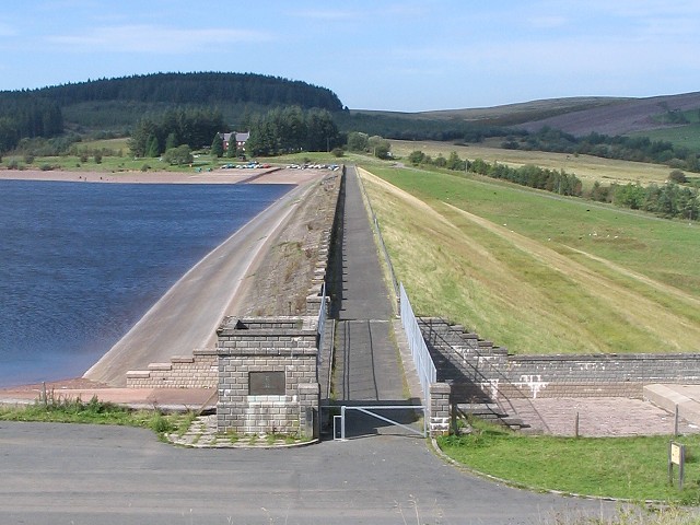
| Talybont Reservoir | 6.2 miles (10 km) | This circular cycling and walking route takes you around the lovely Talybont Reservoir in the Brecon Beacons National Park. The route makes use of National Cycle Route 8 and the Taff Trail to take you around the 318 acres (1.29 km2) reservoir. You start off at the northern end of the reservoir, near the dam, where roadside parking is available. You then climb through the woodland area on the eastern side of the water, along the Taff Trail. There are splendid views over the water to the surrounding hills and beautiful waterfalls near Abercynafon at the southern end of the reservoir. The return leg follows a country lane along the western side of the water and Talybont Forest. View Full Details>> | |
| Tor Y Foel | 4 miles (6.5 km) | This walk climbs to Tor Y Foel in the Brecon Beacons National Park in Powys. View Full Details>> | |
| Usk Reservoir | 5 miles (8 km) | Follow the circular cycling and walking trail around the beautiful Usk Reservoir on this route in the Brecon Beacons National Park. View Full Details>> | |
| Usk Valley Walk | 47.8 miles (77 km) | This super waterside walk follows the River Usk, the Monmouthshire and Brecon Canal and the Brecon and Newport Canal from Caerleon to Brecon. The walk passes through Abergavenny and Usk and is enclosed by beautiful hills for the whole of its length. View Full Details>> | |
| Waun Fach | 7.5 miles (12 km) | Climb to the highest mountain in the Black Mountains on this challenging walk in the Brecon Beacons. The walk starts from Castell Dinas just of the A479. View Full Details>> |