Northumberland National Park Walks
Use the links to view full route information including elevation profiles, interactive maps and GPS downloads.
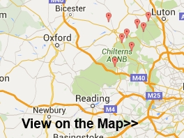
You can also view an overview map of all the routes in the using the Northumberland National Park Walk Map>>
*New* - Walks and Cycle Routes Near Me Map - Waymarked Routes and Mountain Bike Trails>>
| Route Name | Photo | Distance | Description |
| Bellingham | 3 miles (4.8 km) | The village of Bellingham is located in an attractive area of the Northumberland National Park. There's nice riverside trails along the River North Tyne which runs right through the village. You can also pick up the Pennine Way long distance trail or pay a visit to the Hareshaw Linn waterfall, just to the north of the village. This short walk takes you along a riverside path just to the west of Bellingham. It runs for about 1.5 miles on fairly flat paths to Cuddies Loup. On the way you'll pass the lovely Riverdale Hall which has a cricket field and salmon river in its own delightful grounds. There's also nice views of Dunterley Fell to enjoy on the way. Back in the village you can pay a visit to the Grade-I listed St Cuthbert's Church which dates from the 13th century. There's also Bellingham Bridge, a Grade II listed building built in 1834. The Heritage Centre is the local museum. It has exhibitions on the Border Counties Railway, the Border reivers, mining, farming, the photography of W P Collier, and the Stannersburn Smithy. View Full Details>> | |
| Birdoswald | 7.3 miles (11.8 km) | This circular walk explores the fascinating Birdoswald Roman Fort on the Cumbrian section of Hadrian's Wall. The route first explores the fort before following footpaths to other local highlights including the River Irthing, a Roman Quarry, nearby woodland and the village of Gilsland. The walk starts from the English Heritage car park and visitor centre. The fort is the most impressive of the remaining defences along the Wall today. It dates back to AD 122 and includes a well preserved eastern gate, fort walls and watch towers. There's also a museum with an interactive exhibition which details the history of the fort. After exploring the fort you can pick up the Hadrian's Wall Path and follow the waymarked trail along the wall to Turrets 49b and 50b. View Full Details>> | |
| Catcleugh Reservoir | 5.9 miles (9.5 km) | This walk takes you along Catcleugh Reservoir before climbing to Girdle Fell for great views over the Northumberland National Park. The reservoir is located just off the A68 road near Byrness. There's a nice path leading south off the A68 which you can follow along the water. It's a lovely area with the reservoir surrounded by attractive countryside, heather, grassland and a mixture of native and conifer woodlands. It's also great for wildlife spotting with the higher moorland area a breeding ground for golden plover and dunlin. You may also see birds of prey such as buzzards, ospreys and occasionally a golden eagle. Other wildlife to look out for includes otter, red squirrel, badger and roe deer. After passing the southern side of the water the path then climbs past Castle Crag Forest to Girdle Fell. From here there are wonderful views back down to the reservoir. The reservoir is located in Kielder Forest where you can enjoy miles of great cycling and walking trails. Just a few miles to the south you can visit Kielder Water and try the Kielder Forest Lakeside Way. The climb to Deadwater Fell is also just a few miles to the west. From here there are more great views to the Lake District and the Scottish Hills. View Full Details>> | |
| Craster to Seahouses | 9.9 miles (16 km) | This walk follows a lovely section of the Northumberland Coast Path from Craster to Seahouses. Along the way you'll pass lovely beaches, attractive sand dunes, a dramatic coastal castle and a nature reserve with excellent wildlife spotting opportunities. The route runs for about 10 miles, following a reasonably flat section of the long distance St Oswald's Way. As such there is scope for extending the walk if you have time. Starting in Craster you head north past the pretty harbour with its little fishing boats. The route continues to the striking Dunstanburgh Castle. The fortification was built in the 14th century, being one of the largest and grandest castles in Northern England at the time. The dramatic ruins are now a popular tourist attraction, standing on a remote headland with fine views of Embleton Bay and Craster. The walk continues north to the lovely Embleton Bay where there's a nice beach and a sand dune system. Near here you will also pass Newton Pool Nature Reserve where you can use the bird hides to look out for Herons and Barn Owls. The next stage takes you past Newton Haven to Beadnell Bay where there is a lovely long beach. You then pass through the village of Beadnell before starting the final section to Seahouses. This passes the pretty Annstead Burn and Annstead Beach. It's a delightful finish to the walk with more sand dunes and wildlflowers such as Dog Rose and Marram Grass. The walk finishes at Seahouses Harbour, a working fishing port, which also serves the tourist trade, being the embarkation point for visits to the Farne Islands. View Full Details>> | |
| Davidsons Linn | 9.9 miles (16 km) | This walk visits a remote waterfall in the Northumberland National Park. View Full Details>> | |
| Elsdon | 2.5 miles (4 km) | This attractive village in the Northumberland National Park is a lovely place for a stroll. Features include an ancient church, a large village green, the remains of the old motte and bailey castle, a noteworthy Pele tower and views of the lovely Redesdale countryside. View Full Details>> | |
| Greenlee Lough | 6.8 miles (11 km) | This walk visits the pretty Greenlee Lough Nature Reserve from Hadrian's Wall. The reserve is one of the most significant wetland sites in the UK. It includes a variety of habitats including woodland, bog and grassland. The reserve can be reached by following footpaths from Housesteads on Hadrian's Wall. It's about a 3.5 mile walk from the wall with some moderate climbs along the way. You can start the walk from the Housesteads car park and then head north through the fascinating Roman Fort. You then pick up a section of the Pennine Way to take you towards the lake. A footpath then heads west to take you down towards the water. Here you'll find a bird hide where you can look out for a variety of wildlife including wildfowl and waders. There's also lots of interesting plants to see such as 11 species of pondweed and stonewort. View Full Details>> | |
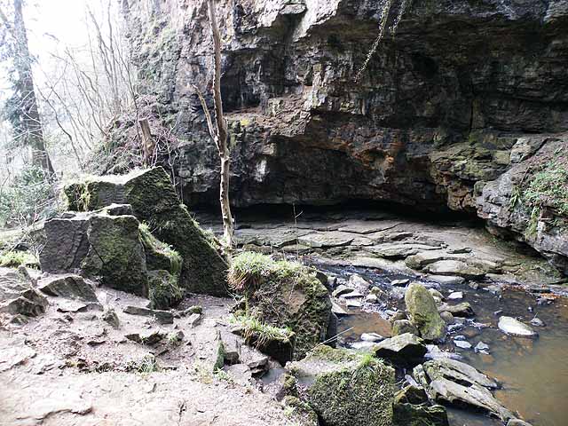
| Hareshaw Linn | 3.1 miles (5 km) | This walk takes you to the beautiful Hareshaw Linn waterfall in the Northumberland National Park. The walk begins in the village of Bellingham and follows footpaths through ancient woodland and over six bridges to the 9 metre high waterfall. On the way you will pass a series of smaller waterfalls on the pretty Hareshaw Burn. Look out for wildlife including red squirrels, great spotted woodpeckers, wood warblers, badgers and bats on the way. The Pennine Way runs past the falls so you could pick this up to continue your walking in the area. View Full Details>> | |
| Hedgehope Hill | 5.6 miles (9 km) | Climb to the 714 metres (2,343 ft) summit of Hedgehope Hill in the Cheviots on this challenging circular walk. The walk begins at the parking area at Langleeford by the Harthope Burn. You then ascend towards Housey Crags and Long Crags and onto the summit where there are fabulous views towards the coast and Lindisfarne Castle. You can descend the same way or head towards Harthope Linn waterfall where you can follow the Harthope Burn back to Langleeford. View Full Details>> | |
| Hindhope Linn | 4.1 miles (6.6 km) | This circular walk visits the beautiful Hindhope Linn and Blakehopeburnhaugh Waterfalls in Kielder Forest. View Full Details>> | |
| Housesteads | 4 miles (6.5 km) | Visit the fascinating Housesteads Roman Fort on this circular walk around Hadrian's Wall in the Northumberland National Park. The fort dates from AD 124 and includes a barracks block, hospital, Commander's House, granaries and communal toilets which are all still visible today. You can start the walk from the Housesteads car park on the Military Road just south of the fort. You then climb steadily up to the fort where you can explore the buildings and enjoy wide ranging views over the surrounding countryside, woodland and hills. The walk then heads west along Housesteads Crags and Hotbank Crags where you can actually walk on a section of the wall. Just before Crag Lough you turn north and then east, following another footpath past Ridley Common and Broomlee Lough. After rounding King's Wicket, you pass Milecastle 36, King's Hill and Clew Hill before returning to the fort and the car park. To extend your walk you can continue west along the path and visit the iconic Sycamore Gap. The famous tree was voted England's tree of the year in 2016. It is located just over a mile west of Housesteads near to the pretty Crag Lough. Another option is to pick up the Pennine Way and follow it between Broomlee Lough and Greenlee Lough towards Haughton Common. Greenlee Lough is also a nature reserve and one of the most significant wetland sites in the UK. If you head east along Hadrian's Wall Path you will soon come to Carrawburgh which was the site of a 3˝ acre auxiliary fort. View Full Details>> | |
| Humbleton Hill | 5 miles (8.1 km) | Enjoy a walk to Humbleton Hill from Wooler and take in the great views over the Cheviot Hills. The walk starts in the popular walking town of Wooler. Begin by following country lanes west out of the town to Wooler Common where you can pick up a trail along the Humbleton Burn. After about a mile you turn north, following a section of the St Cuthbert's Way past Brown's Law. You then branch to the right to pick up the trails that will take you up to the Humbleton Hill summit. Here you will find the remains of an Iron Age hillfort and splendid views towards Yeavering Bell, the Northumberland coast and the Scottish Hills. The hill is also of historical significan being the site of the Battle of Homildon Hill fought between the English and Scottish armies in 1402. View Full Details>> | |
| Ingram Valley | 13.7 miles (22 km) | This walk takes you on a tour of the beautiful Ingram River Breamish Valley in the Northumberland National Park. You'll pass along rivers and burns with miles of open moorland and the Cheviot Hills making a splendid backdrop. The walk starts at the village of Ingram and heads west along the River Breamish and the Greensidehill burn towards Brough Law and Linhope. At Hartside you turn south and head towards Alnhamoor crossing the river as you go. You continue to Little Dod before picking up Salter's Road (a track) to climb High Cantle hill. You continue east towards Linhope where you can take a short detour to visit the splendid Linhope Spout waterfall. From Linhope you soon pick up the country lane from the start of the walk which will return you to Ingram. If you'd like to continue your walks in the area then you could climb the nearby Hedgehope Hill and The Cheviot. View Full Details>> | |
| Kielder Forest Lakeside Way | 21.7 miles (35 km) | This fantastic circular cycling and walking route takes you around the beautiful Kielder Water in Kielder Forest Park, Northumberland. The route is known as the Lakeside Way and follows the shoreline of the reservoir on a lovely multi-user track. Along the way you can see twenty pieces of outdoor public art including the futuristic Belvedere shelter and the three large rotating Janus Chairs. There's excellent wildlife spotting opportunities with Ospreys regularly seen around the reservoir. The route also passes Kielder Dam and Kielder Castle where you will find an excellent visitor centre with exhibitions, information and a cafe. The castle is also the centre for cycling within the park - you can hire a bike here or get your own repaired. It is located at the northern tip of the reservoir at Kielder village. If you're looking for a more challenging cycle ride you will also find several colour coded mountain bike trails within the park. They range from the easy Borderline trail to the thrilling Deadwater black trail. For great views over the Lake District and the Scottish Hills you could climb Deadwater Fell from Kielder Castle. A few miles to the north there's a nice climb to Girdle Fell with great views over the lovely Catcleugh Reservoir. View Full Details>> | |
| Kyloe Woods | 4.3 miles (7 km) | This walk visits Kyloe Woods in the Northumberland National Park. It's a peaceful and serene place which is somewhat off the beaten track. View Full Details>> | |
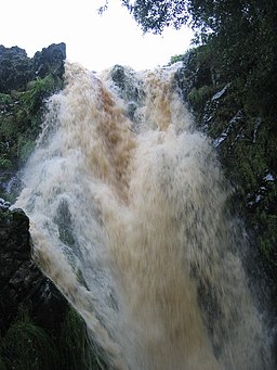
| Linhope Spout | 3.1 miles (5 km) | This short walk takes you to this lovely waterfall in the Ingram Valley. The walk starts at Hartside where there is parking available by the roadside. You then follow a country lane to Linhope where you cross the River Breamish and ascend to the waterfall and Linhope burn on public footpaths. The waterfall is an impressive 60 foot (18m) chute of water landing into a deep plunge pool below. On the walk there are splendid views of Great Standrop and Hedgehope Hill. Look out for Curlew and red squirrels on the way. Our Ingram Valley and River Breamish Valley circular walks both pass close to the falls. For a longer walk you could start from the Ingram Bridge car park and follow either of these trails to Linhope. Back in Ingram there's the option of visiting the nice Ingram Cafe where there's a good range of meals and snacks to enjoy after your exercise. If you'd like to continue your walking in the area then you could climb the nearby Hedgehope Hill and The Cheviot. View Full Details>> | |
| Otterburn | 2.2 miles (3.5 km) | This circular walk follows the Otterburn Village Trail around this Northumberland village. It runs for just over 2 miles with nice views of the surrounding countryside on the way. The walk starts in the village and follows the trail north along the waters of the pretty Otter Burn. This takes you up to Otterburn Hall, a country house situated in 500 acres (200 ha) of deer park and woodland. It's an attractive building, Grade-II listed with English Heritage, and rated with four-stars by the Architectural Association School of Architecture. From the hall you head east and then south to follow the trail through Girsonfield and back into the village. View Full Details>> | |
| River Breamish Valley | 13 miles (21 km) | This circular walk takes you along a lovely section of the River Breamish in the Cheviots. Start the walk from the village of Ingram where there is a handy public car park. Follow country lanes west towards the hill of Brough Law where there are the remnants of a Bronze Age settlement. The route then climbs to Hartside Hill where there are more ancient settlements, a cairn and fine views over the area. From the hill summit the route descends to the River Breamish where you can pick up some nice riverside paths. Bridleway lead you west to High Cantle where the route turns east toward Linhope. Here you can take a small detour from the route to visit Linhope Spout waterfall. The waterfall is an impressive 60 foot (18m) chute of water landing into a deep plunge pool below. After passing Linhope the route returns to the car park in Ingram, passing Hartside on the way. For an aternative route around the valley try our Ingram Valley Walk which visits Little Dodd. You could also try the climb to The Cheviot for fabulous views over the valley and beyond. View Full Details>> | |
| Rothbury | 8 miles (12.8 km) | Rothbury is located in the Northumberland National Park on the edge of the Simonside Hills. There's lovely walks through Coquetdale into the surrounding hills and the wonderful Cragside to visit. As such the town is a popular base for walkers looking to explore this scenic area. This circular walk starts in the town centre and picks up the riverside path along the River Coquet. The route then leaves the river and climbs to Newtown and Great Tosson where you enter a woodland section at Windy Crag. The path then climbs through the woods to the Simonside Hills, where you reach a height of nearly 1400ft (426m). There's fabulous views here over the town to the surrounding hills and countryside. The route then descends through Newtown Park to Rothbury Forest where you will pass an old fort and some intersting geological rock formations. The area includes Lordenshaw Hill which has the largest concentration of rock carvings in Northumberland. The carved panels range from single cup-marked boulders to more complex panels. There are many other interesting archaeological sites in this area, including a ditched Iron Age enclosure and an Early Bronze Age cairn. The final section passes Garleigh Moor before descending to Whitton and crossing the river to return to the town. On this section you'll pass the 14th century Whitton Tower which is exceptionally well-preserved. View Full Details>> | |
| Simonside Hills | 6.8 miles (11 km) | The Simonside Hills are a fabulous place for walkers with miles of footpaths taking you through woodland and moorland to wonderful viewpoints. You'll pass interesting rock formations, rocky outcrops and acres of forest as you make your way through this wildly beautiful area of the Northumberland National Park. View Full Details>> | |
| St Cuthberts Cave | 2.1 miles (3.4 km) | This walk visits an interesting Sandstone cave near Belford in Northumberland. The monks of Lindisfarne reputedly brought St. Cuthbert's body to the site in AD875 following Viking raids on the Island. View Full Details>> | |
| Sycamore Gap | 3.4 miles (5.5 km) | Sycamore Gap was voted England's tree of the year in 2016. It stands in a dramatic dip next to Hadrian's wall in the Northumberland National Park. The tree is known as the 'Robin Hood' tree after famously featuring in the film 'Robin Hood Prince of Thieves' starring Kevin Costner. This circular walk makes use of the Hadrian's Wall Path and the Pennine Way to take you to the iconic tree and around the pretty Crag Lough. The walk starts at the Steel Rigg car park just to the west of the tree. You then pick up the footpath to Steel Rigg and on to Sycamore Gap. After taking some photos of the strikingly positioned tree the path continues around Crag Lough. The route then follows public footpaths back to the car park, passing Hound Hill on the way. You can extend your walk by continuing east along the path to Hotbank Crags and Housesteads Wood. Here you can physically walk on Hadrian's Wall for a short section. There's some magnificent views on this elevated section of the path. If you keep heading east you will soon come to the famous Housteads Roman Fort. The fascinating fort dates from AD 124 and is well worth a visit. The barracks block, hospital, Commander's House, granaries and communal toilets are all still visible today. You can virtually explore the footpath around Sycamore Gap on the google street view link below. View Full Details>> | |
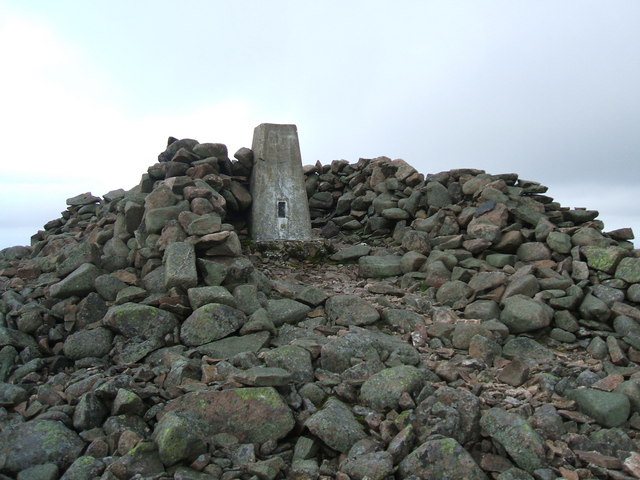
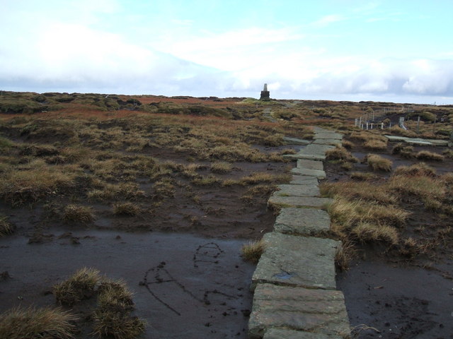
| The Cheviot | 8.7 miles (14 km) | This circular walk climbs to the 815 m (2,674 ft) summit of the highest hill in the Cheviot hills. The walk begins at the parking area at Langleeford by the Harthope Burn. The route then ascends along public footpaths and with the burn on your left. You continue to Cairn Hill passing the pretty Harthope Linn waterfall on the way. At Cairn Hill you pick up the Pennine Way to take you to the summit. This section takes place on stone slabs through an area of peat bog. At the summit you can enjoy excellent views of the North Sea, the Lake District Fells, Cross Fell and the Lammermuir Hills. You then descend back to Langleeford via Scald Hill. View Full Details>> | |
| Usway Burn - River Coquet - Upper Coquetdale Walk | 13.7 miles (22 km) | Enjoy some lovely waterside walking along the Usway Burn and the River Coquet on this route in the Upper Coquetdale area of the Northumberland National Park. The walk begins next to the parking area at Alwinton and follows a footpath to the Usway Burn. You follow the path north along the burn with waterfalls, woodland paths and wonderful views of the Cheviots. Just after entering the edge of Kidland Forest you turn south and head towards Barrowburn. View Full Details>> | |
| Walltown Crags | 3.7 miles (6 km) | Visit one of the best preserved sections of Hadrian's Wall on this short walk in Northumberland. The walk starts at the car park near Greenhead and follows the Hadrian's Wall Path to Walltown Crags. There are splendid views towards Haltwhistle and the River South Tyne. View Full Details>> | |
| Windy Gyle | 9.9 miles (16 km) | Climb to the summit of this hill in the Cheviots and enjoy fabulous views into Scotland and England as you stand high on the border. This challenging circular route runs for a distance of about 10 miles using the bridleways and footpaths that cross the area. The walk begins from the Wedder Leap car park and heads towards Shorthope hill, crossing the River Coquet and following the Rowhope Burn as you go. You continue the climb to Little Ward Law before coming to Russel's Cairn at the 619 m (2,031 ft) summit of Windy Gyle. From here there are wonderful views over the Scottish Borders, the Eildon Hills and Edinburgh. You begin the descent by heading west along the Pennine Way and then south towards Swineside Law and Hindside Knowe. Shortly after you cross the River Coquet and return to the car park. This is a challenging walk but the footpaths are generally good and you're rewarded with some stunning scenery. To continue your walking in the Cheviots you could climb the highest hill - The Cheviot. View Full Details>> | |
| Wooler Common | 3.7 miles (6 km) | Explore this attractive area of woodland and common land on this walk in the Northumberland National Park. It's a very peaceful area with lovely views of the Cheviot Hills, two pretty ponds and an easy access trail to try. The town of Wooler is a popular base for walkers with direct access to the Cheviot Hills. The common is also a short walk from the town centre. Just follow the St Cuthbert's Way long distance trail south west and you soon come to the site. View Full Details>> | |
| Yeavering Bell | 3.1 miles (5 km) | Climb to the summit of this hilll in the Cheviots and visit the largest Iron Age hillfort in the region. The walk starts near Kirknewton at the Gefrin lay-by where there is some roadside parking. From here you head south climbing to the fort on public footpaths and the St Cuthbert's Way long distance path. View Full Details>> |