Goss Moor Trail
![]()
![]() This super Cornish trail is suitable for both walkers and cyclists and takes you on a tour of the 480 hectare Goss Moor National Nature Reserve.
This super Cornish trail is suitable for both walkers and cyclists and takes you on a tour of the 480 hectare Goss Moor National Nature Reserve.
The heathland includes waterways, marshes and still pools with the Screech Owl Sanctuary providing another highlight. The site is home to a number of rare species including silver-studded blue, marsh fritillary, small pearl-bordered fritillary and grizzled skipper butterflies.
The circular route can be accessed easily from St Columb Road Rail Station near the village of Indian Queens on the eastern side of the moor. It links up with National Cycle Route 305 which will take you to the famous Eden Project from the reserve.
Goss Moor Trail Ordnance Survey Map  - view and print off detailed OS map
Goss Moor Trail Open Street Map  - view and print off detailed map
Goss Moor Trail OS Map  - Mobile GPS OS Map with Location tracking
Goss Moor Trail Open Street Map  - Mobile GPS Map with Location tracking
Further Information and Other Local Ideas
A few miles to the north west you will find some pleasant waterside trails around Porth Reservoir. Near here there's also peaceful woodland paths to be found in Colan Woods.
To the east you can explore Bodmin Moor and enjoy climbs to Helman Tor and Roche Rock.
Just a few miles to the south you'll find the little village of Ladock and Ladock Woods. It's a serene place with pleasant woodland trails and some nice views of the Tresillian River in the village. Ladock also includes a 17th century pub which is worthy of some investigation.
Just to the south there's the Tregargus Valley where you can enjoy woodland walks along the River Fal. There's also interesting industrial history with a series of old mine buildings and the old China Clay Works at Goonvean Quarry.
For more walking ideas in the area see the Cornwall Walks page.
Cycle Routes and Walking Routes Nearby
Photos

The Goss Moor Trail. A few years ago this was the A30, the main arterial route through Cornwall. This has been replaced by a new dualled road to the north and the old road has been turned into a footpath and cycleway across the moor.

Reflection in pond. A flooded pit on the Goss Moor nature reserve

Road into Goss Moor. This road flanks the southern edge of the moor. At the start of the road is a cattle grid and a gate at the side wide enough to let horse-drawn vehicles through.

The River Fal. The river rises on the moor at Pentivale and flows 17 kilometres (11 mi) to the English Channel at Carrick Roads. The sand on the bank does not look natural. Perhaps it has been dredged out of the river bottom in order to help stop the river changing course and flooding the surrounding moor.

Cattle Pasture at Trerice. This grid square is mainly pasture land sandwiched between the china clay industry and the heathland of the moor.

View over the moor. The moor is notable as the largest continuous mire complex in south-west Britain and consists of mainly peatland and lowland heath.

One of the trails on the moor.

St Dennis, a large village in Cornwall's clay country. To the south and west of the village are the china clay workings on the St Austell Granite and to the north, agricultural land leading down to Goss Moor. This photograph was taken near the centre of the village and features a village shop which, according to the sign has been operating since 1850.
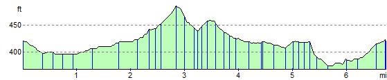
Elevation Profile