Dolwyddelan Castle Walk

 This circular walk visits a historic castle located in the Conwy County area of North Wales. It's a beautiful area with the stunning scenery of the Snowdonia National Park and the Afon Lledr valley to enjoy.
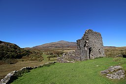
The walk starts from Dolwyddelan train station and heads north to cross the River Lledr. You then turn west to follow a footpath up to Bron Llewelyn and then on to Dolwyddelan castle. It was built during the early part of the 13th century by Llywelyn the Great. The castle was then finally conquered during the reign of his grandson Llywelyn ap Gruffudd by the King Edward I in 1283. It was a significant moment in his relentless campaign to crush the Welsh. Today from the remaining castle ruins here there are fabulous views over the surrounding countryside and Snowdonia mountains from the elevated position of the site.
The route then descends back to the river and Roman Bridge Station before returning on other public footpaths through woodland to the south of the river.
Please click here for more information
Dolwyddelan Castle Ordnance Survey Map  - view and print off detailed OS map
Dolwyddelan Castle Open Street Map  - view and print off detailed map
Dolwyddelan Castle OS Map  - Mobile GPS OS Map with Location tracking
Dolwyddelan Castle Open Street Map  - Mobile GPS Map with Location tracking
Pubs/Cafes
The Y Gwydyr pub does good home cooked food in the village. There's also a good selection of ales and a nice garden area to relax in if the weather is good. You can find it on Caernarfon Rd with a postcode of LL25 0EJ for your sat navs. The pub is also dog friendly if you have your canine friend with you.
Further Information and Other Local Ideas
The giant Moel Siabod towers over the village. It's located just to the north and can be climbed on the Moel Siabod Walk. The mountain reaches a peak of 872m making it the highest peak in the Moelwynion mountain range. You can start the circular walk from Pont Cyfyng which is also very picturesque.
The village of Capel Curig is also to the north and makes an excellent base for walkers. From here you can visit the lovely Llyn Cowlyd where there are some nice waterside trails.
For some interesting local history try the Dolgarrog Pipeline Walk. This explores the area around the little village, visiting the impressive pipeline structure and the Coedty reservoir. Near here there's also the beautiful Llyn Eigiau where the reservoir dam was breached leading to the Dolgarrog Dam disaster of 1925.
The Fishermans Walk and Lledr Gorge Walk starts just to the east of the settlement at Pont-y-Pant railway station on the Conwy Valley line. This takes you through the beautiful scenery of the Lledr Gorge with its picturesque waterfalls, stepping stones and Pont Gethin viaduct. There's also the option of trying the Victorian Fishermans Walk, a precarious route through the gorge on a rickety old walkway.
For more walking ideas in the area see the Snowdonia Walks page.
Cycle Routes and Walking Routes Nearby
Photos
Dolwyddelan station. View NE, towards Llandudno Junction: ex-LNW Llandudno Junction - Blaenau Ffestiniog line. Not only still open - but 'rebuilt'.


