Winter Hill
![]()
![]() Enjoy a walk to Winter Hill on the West Pennine Moors in Lancashire. The walk begins in Rivington Country Park and takes you to the 1,496 feet (456 m) high summit on a series of footpaths.
Enjoy a walk to Winter Hill on the West Pennine Moors in Lancashire. The walk begins in Rivington Country Park and takes you to the 1,496 feet (456 m) high summit on a series of footpaths.
After leaving the country park you ascend crossing Rivington Moor with fine views of Rivington Reservoir and Anglezarke Reservoir. You continue towards the village of Belmont where there is the opportunity for a short detour to the pretty Belmont Reservoir. After leaving Belmont you ascend towards the summit of the hill where you will see the Winter Hill TV Mast. From here there are fabulous views towards Greater Manchester, Blackpool Tower, Jodrell Bank Observatory, Snaefell in the Isle of Man and the Lake District mountains.
The descent takes you to Crooked Edge Hill and Horwich before returning to the country park.
To continue your walking in the area try the climb to the nearby Rivington Pike. It's another very popular hike with an ascent through the old Lever Park terraced gardens and more great views from the summit.
Winter Hill Ordnance Survey Map  - view and print off detailed OS map
Winter Hill Open Street Map  - view and print off detailed map
Winter Hill OS Map  - Mobile GPS OS Map with Location tracking
Winter Hill Open Street Map  - Mobile GPS Map with Location tracking
Pubs/Cafes
On the eastern side of Rivington Reservoir you could enjoy some refreshments in the delightful Rivington Village Green Tea Room. There's a cosy interior where you can enjoy a good range of snacks and meals. There's also an outdoor area for warmer days and the cafe is very dog friendly too. You can find the tea rooms on Sheep House Lane with a postcode of BL6 7SD for your sat navs.
The Black Dog in the village of Belmont is only about a mile north east of the hill summit. The fine country pub has an interesting history having been opened back in 1825. The original building was first used as a village courthouse in the 1700s and later as a farmhouse. It has a fine interior with cosy snugs, raised areas, coal fires and traditional features. At the back of the pub there’s a sun-trap beer garden and part-covered courtyard. It's an ideal place to relax in after your walk if the weather is good. They also provide accommodation if you need to stay over in the area. You can find the pub in the village on Church Street with a postcode of BL7 8AB. It's located very near to Belmont Reservoir and Ward's Reservoir which make for a nice stroll after your meal.


Pictured above: the Black Dog and Ward's Reservoir in Belmont.
Dog Walking
The open moorland surrounding the hill is a great place to explore with your dog. The woodland trails to the west of the hill around Rivington are also ideal for dog walking.
Cycle Routes and Walking Routes Nearby
Photos
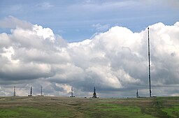
Winter Hill Masts. The hill's prominent position made it the ideal site for the TV Mast, which transmits to a large area of North West England. There is also a number of other telecommunication masts and towers around the summit and side of the hill for mobile phones, Professional Mobile Radio users and emergency services.
The hill is a designated 'Right to Roam' area making it very popular with walkers. There are some also some interesting historical connections with site. In 1896 10,000 people marched from Bolton to the open countryside in a mass demonstration after the owner of the Smithills Hall estate, Colonel Richard Henry Ainsworth tried to stop public access, the demonstrators repeated the march the following week and were met with no opposition to them accessing the moors, it is considered an early forerunner of the Kinder Scout mass trespass. The demonstration is commemorated by a memorial stone on Coal Pit Lane, below Smithills Moor.
Winter Hill from Parbold Hill. The hill is classified as a Marilyn and marks the highest point in Blackburn with Darwen.
Noon Hill Tumulus, located just south west of the hill top. The summit of Noon Hill is home to a Bronze Age burial mound which is listed under the Ancient Monuments and Archaeological Areas Act. The burial monument, sometime known as the Noon Hill Saucer Tumulus is one of a pair of such burial mounds. The other being around 1 kilometre to the east, towards the summit of Winter Hill. The mound has been dated to around 1100 BC.


