Itchen Way
![]()
![]() Follow the River Itchen from its mouth at Woolston to its source near Hinton Ampner on this beautiful waterside walk.
Follow the River Itchen from its mouth at Woolston to its source near Hinton Ampner on this beautiful waterside walk.
You start near Woolston station near Southampton Docks and head north through Southampton to a lovely riverside park near Swaythling and the Itchen Valley Country Park. The path continues past Southampton Airport and through Eastleigh before arriving at Winchester with its impressive cathedral. Here you can take a small detour to climb the lovely St Catherine's Hill and enjoy fine views over the town below, the River Itchen and the surrounding countryside of the South Downs.
From Winchester you then turn east towards Itchen Abbas and New Alresford with the final section passing through Cheriton and finishing at National Trust owned
Hinton Ampner.
Itchen Way Ordnance Survey Map  - view and print off detailed OS map
Itchen Way Open Street Map  - view and print off detailed map
Itchen Way OS Map  - Mobile GPS OS Map with Location tracking
Itchen Way Open Street Map  - Mobile GPS Map with Location tracking
Pubs/Cafes
The Otter pub in the village of Otterbourne is a worthy place for a pit stop. The historic pub dates back 300 years and sits in a lovely location overlooking the village green. They serve a fine Sunday roast and have a fine garden area to sit out in on warmer days. You can find them at Boyatt Lane with postcode S021 2HW. The pub is also dog friendly if you have your canine friend with you.
At the end of the walk in Cheriton there's the The Flower Pots for some well earned refreshments.
The attractive red brick building dates back to the 1830s when it was originally a farmhouse. They serve fine food and have a lovely large garden area to relax in.
You can find them at Brandy Mount, SO24 0QQ.
The pretty village is a pleasant place for a stroll too. There's a 13th century church some picturesque thatched cottages and the site of the Battle of Cheriton which took place as part of the English Civil War in 1544. This is located about a mile east of the village near Cheriton Wood where there's some peaceful woodland trails to enjoy.
Further Information and Other Local Ideas
Just west of the trail in Southampton you can head west to visit the expansive Southampton Common. There's nice walking and cycling trails here with woodland and a number of pretty lakes.
At Itchen Abbas you could take a small detour from the path to visit the lovely Avington Park on the south side of the river. There's a picturesque lake, peaceful woodland and a herd of highland cattle to see here. See the circualar Itchen Abbas Walk for more details.
The Three Castles Path is coincident with the trail around Winchester. This historically themed long distance trail will take you from Windsor Castle to Winchester Castle, visiting the ruined Odiham Castle on the way.
The route is coincident with the St James' Way. The long distance pilgrimage route runs from the historic ruins of Reading Abbey to the coast at Southampton.
For more walking ideas in the area see the Hampshire Walks and South Downs Walks pages.
Cycle Routes and Walking Routes Nearby
Photos

River Itchen and start of the Itchen Way. Bridge on Kilmeston Road over the dry channel which leads from one of the largest springs that form the source of the River Itchen.

Heading north across a field of brassicas south of Tichborne House.

Grassy path on the trail. The Itchen Way and Three Castles Path heading towards Winchester south of the footbridge to Abbots Worthy.

Winnall. A stile on the trail. The tall conifers on the left screen the fishing lakes.

The footpath at Itchen Abbas. Heading west along the southern edge of the village.

Avenue of Beech trees on the trail at Shawford. Looking N. Itchen Navigation is off picture to left. This avenue doesn't lead anywhere but it is deliberately planted with alternating green and copper beeches

Footbridge over the River Itchen to Itchen Stoke. A footpath from Lovington Lane to Itchen Stoke crosses the River Itchen here. The white chalk crosses were marked all along a circular route along footpaths in this area. The yellow arrow on the nearest wooden post on the bridge indicates the route of the Itchen Way path.

River Itchen at Itchen Abbas. Approaching Chilland
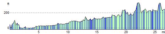
Elevation Profile