Matlock to Matlock Bath and Cromford River Circular Walk
![]()
![]() The county town of Matlock is a great base for exploring the south eastern edge of the Peak District. This circular walk from the town takes you to High Tor and past the Heights of Abraham. You'll also enjoy a riverside stretch along the River Derwent on the Derwent Valley Heritage Way. This runs south to Matlock Bath and Cromford passing High Tor on the way. From the distinctive limestone crag there are splendid views over the town to the Peak District hills beyond. The route then heads north west towards Bonsall before following the Limestone Way back into Matlock.
The county town of Matlock is a great base for exploring the south eastern edge of the Peak District. This circular walk from the town takes you to High Tor and past the Heights of Abraham. You'll also enjoy a riverside stretch along the River Derwent on the Derwent Valley Heritage Way. This runs south to Matlock Bath and Cromford passing High Tor on the way. From the distinctive limestone crag there are splendid views over the town to the Peak District hills beyond. The route then heads north west towards Bonsall before following the Limestone Way back into Matlock.
Please scroll down for the full list of walks near and around Matlock. The detailed maps below also show a range of footpaths, bridleways and cycle paths in the area.
Matlock Ordnance Survey Map  - view and print off detailed OS map
Matlock Open Street Map  - view and print off detailed map
*New* - Walks and Cycle Routes Near Me Map - Waymarked Routes and Mountain Bike Trails>>
Matlock OS Map  - Mobile GPS OS Map with Location tracking
Matlock Open Street Map  - Mobile GPS Map with Location tracking
Walks near Matlock
- High Tor Matlock - This circular walk takes you to High Tor hill between Matlock and Matlock Bath. The impressive limestone crag is just over a mile from the town centre and the train station
- Heights of Abraham - Ride a cable car to the Hilltop Park and enjoy magnificent views of the Derwent Valley and surrounding Peak District at this major attraction in Matlock
- Lumsdale Valley - This splendid walk takes you from Matlock to the beautiful wooded gorge of the Lumsdale Valley
- Derwent Valley Heritage Way - Follow the River Derwent through the Derbyshire Peak District on this stunning walk
- Cromford Canal - Enjoy a waterside stroll along the Cromford Canal on this easy walk in Derbyshire
- Limestone Way - Travel through the beautiful Peak District National Park on this walk through Derbyshire and into Staffordshire.
The walk starts at Castleton, passing through the scenic Cave Dale and past the remains of Peverill Castle - Stanton Moor - This upland area near the Derbyshire village of Stanon-in-Peak has good walking trails, attractive woodland and fascinating ancient historical sites to visit.
You can start the walk at the village of Stanon-in-Peak near Matlock - Ogston Reservoir - This beautiful reservoir near the Derbyshire village of Brackenfield is one of Derbyshire's premier bird watching sites
- Lovers Walk Matlock Bath - The Lovers Walk in Matlock Bath take you along the River Derwent and through the adjacent woodland
- Brassington - This attractive Derbyshire Dales village is close to a number of popular waymarked trails and a major local reservoir
- Wirksworth - This circular walk around the Derbyshire town of Wirksworth uses various footpaths to visit some of the highlights of the area.
Starting in the town you head north and pick up the High Peak Trail to take you up to the Black Rocks around Cromford - Middleton Top - At Middleton Top you will find an excellent visitor centre with a number of good walking trails to try
- Carsington Water - This route follows the circular cycling and walking trail around Carsington Water in Ashbourne, Derbyshire
- Robin Hood's Stride - This walk visits Robin Hood's Stride, a wonderful rock formation near Bakewell in Derbyshire.
- Birchover - This Peak District village is a fine place to start a walk
- Nine Ladies Stone Circle Walk - This walk visits the fascinating Bronze Age stone circle of the Nine Ladies in the Derbyshire Peak District.
- Wingerworth - This attractive Derbyshire village is located just to the south of Chesterfield.
Pubs/Cafes
In the town the Sycamore Inn is a nice place for some post walk refreshments. It's set in an old coaching inn and does excellent home-cooked food. There's also a lovely garden area which includes a boules pitch. It's a fine place to relax on a summer day. You can find them at postcode DE4 3HZ for your sat navs.
Dog Walking
The area is fine walking country with lots of woodland and river trails for you and your pet. The Sycamore Inn mentioned above is also dog friendly.
Further Information and Other Local Ideas
Matlock is located near to the village of Crich, known as the location for the setting for the ITV series Peak Practice and the excellent Crich Tramway Village. This fascinating museum contains over 60 trams built between 1873 and 1982 and is set within a recreated period village containing a working pub, cafe, old-style sweetshop and tram depots. It's located just a few miles south east of the town and well worth a visit.
Just to the south of the town there's another significant local attraction in the form of Cromford Mill. The site is a significant part of the wider Derwent Valley Mills UNESCO World Heritage Site. It includes the world's first successful water powered cotton spinning mill which was built in 1771 by Sir Richard Arkwright.
Head a few miles south west and you could pick up the circular Brassington Walk and visit Middleton Top and the expansive Carsington Water.
A few miles to the west there's Birchover where you can visit the Bronze Age Nine Ladies Stone Circle and the wonderful rock formations at Robin Hood's Stride.
For more walking ideas in the area see the Derbyshire Walks page.
Photos
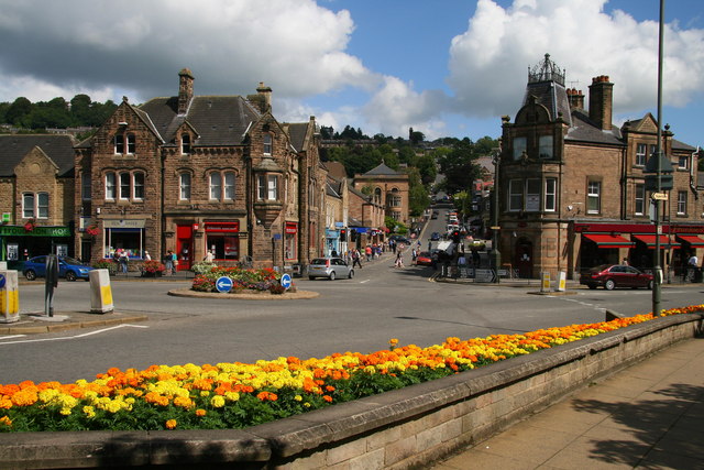
Bank Road, Matlock Looking up Bank Road towards Matlock Bank. Crown Buildings on the right facing the roundabout was built in 1889.


