Clonakilty Walks
![]() Clonakilty is a vibrant and welcoming seaside town located in the heart of West Cork, in the southern region of Ireland. Renowned for its multi-award-winning status, it boasts a cosmopolitan atmosphere and a friendly community spirit.
Clonakilty is a vibrant and welcoming seaside town located in the heart of West Cork, in the southern region of Ireland. Renowned for its multi-award-winning status, it boasts a cosmopolitan atmosphere and a friendly community spirit.
This walk from the town takes you along the lovely Clonakilty Harbour to Inchydoney Island. The Island is a popular tourist spot with a beautiful Blue Flag Beach.
The walk takes you south from the town passing the splendid West Cork Model Railway Village before picking up a waterside path along the harbour. There are wonderful views across the water to the surrounding countryside on this trail.
You'll soon come to Inchydoney Island where you can enjoy a coastal walk with more fine views out to sea.
To continue your walking in the area head east along the coast and you could pick up the popular Seven Heads Walk. There's a long circular trail to follow around the picturesque peninsula with pretty seaside villages, lovely beaches and bays.
Clonakilty Open Street Map  - view and print off detailed map
Ireland Walking Map - View All the Routes in the Country>>
Clonakilty Open Street Map  - Mobile GPS Map with Location tracking
Further Information and Other Local Ideas
A few miles to the east there's another local highlight at Charles Fort. The National Monument of Ireland dates back to the 17th century and includes good footpaths to follow around the Bastions. There's also some excellent views over Kinsale harbour and exhibitions where you can learn all about the history of the area.
Also to the east there's more cliff top walking on the Crosshaven Cliff Walk. This fine circular walk provides wonderful views over Cork Harbour and visits the 16th century Camden Fort Meagher.
Near Cork there's the 13th century Blarney Castle to explore. The ancient castle is surrounded by some beautiful grounds and gardens with miles of footpaths to enjoy.
Head west towards Skibbereen and you could visit Lough Hyne. Here you will find a significant Marine Nature Reserve with cliffs, salt marsh, beach and a popular circular walking trail. Near here there's also the deep purple fuchsia on the Courtmacsherry Loop Walk and Galley Head where you can explore the sand dunes at Long Strand beach before heading towards the 19th century lighthouse at the end of the headland.
Cycle Routes and Walking Routes Nearby
Photos
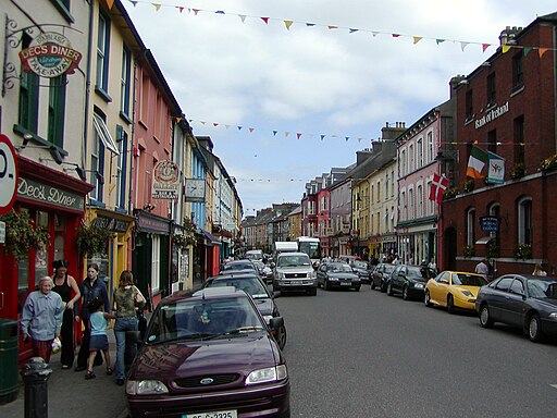
Clonakilty town centre. Clonakilty serves as a central tourism hub in West Cork and has garnered prestigious accolades for its charm and appeal. In 2017, it was honoured with the title of "Best Town in Europe" and also recognised as the "Best Place of the Year" by the Royal Institute of the Architects of Ireland.
Rocky Outcrops to West of Inchdoney Island headland. Having walked out on to the headland in front of the Inchydoney Island hotel this is the western side of the headland and view beyond.
Looking up at the Inchdoney Island Hotel. Inchydoney is a popular tourist destination boasting two stunning beaches, each situated on either side of the Virgin Mary headland. During the summer months, a lifeguard station is set up on the headland for a period of three months, ensuring the safety of beachgoers. The island holds historical significance, having been granted by Queen Elizabeth I to the Church of Ireland Bishop of Ross in 1584. Amidst the turmoil of the Irish Confederate Wars, a notable event occurred when a Protestant force led by Lord Forbes recaptured the town of Clonakilty from Catholic rebels in 1642. Following this, several hundred rebels attempted to seek refuge on the island of Inchydoney. Tragically, they were intercepted and drowned by the rising tide before reaching the shores of Inchydoney.
Clonakilty model village. The Model Village is a tourist attraction and includes fully scaled models of Clonakilty and nearby towns – built on a miniature of the area's railway line.
Emmet Square Clonakilty. Michael Collins House is a museum dedicated to the Irish revolutionary leader Michael Collins. The museum is set out in a restored Georgian townhouse on Emmet Square, where Collins lived from 1903 to 1905. Visitors can explore the museum's exhibits, interactive displays, and historical artifacts to learn about Collins' life and the history of Irish independence. Guided tours are also available to provide deeper insights into Collins' legacy and his contributions to Ireland's struggle for independence.
Michael Collins, was the Director of Intelligence for the Irish Republican Army (IRA) during the Irish War of Independence, spending his formative years in Clonakilty and attending the local boys' national school. His pivotal role continued as he later served as Chairman of the Provisional Government of Ireland, playing a crucial part in the establishment of the Irish Free State. Collins fell victim to an ambush by the Anti-Treaty IRA during the Irish Civil War.
Collins maintained a strong connection to Clonakilty throughout his life, delivering several speeches from O'Donovan's Hotel on the Main Street. A testament to his legacy stands in Emmet Square, where Collins resided for a period—a statue erected and dedicated in 2002 pays tribute to his memory.


