Cork Marina Walk
![]() This circular walk explores some of the quieter and more scenic areas of the city of Cork.
This circular walk explores some of the quieter and more scenic areas of the city of Cork.
You'll pass along waterside paths on the River Lee and visit the Marina Park on Cork's historic Marina.
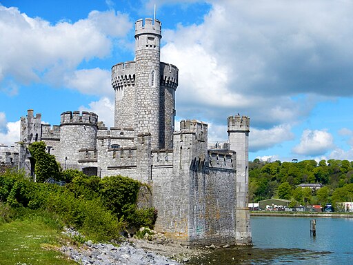
There's also more interesting local history to enjoy at the 16th century Blackrock Castle where you'll find a visitor centre and a cafe for refreshments.
After exploring the castle, follow the riverside paths towards Jacob’s Island and Joe McHugh Park, where you'll soon spot the Passage Railway Greenway across the Tramore River.
The Greenway then takes you through Mahon and back to the Marina.
This greenway is a shared-use path that links Cork City with Passage West, tracing the route of an old railway that ceased operation in 1932.
Some of the route is also open to cyclists including the surfaced greenway.
To continue your walking around Cork head north west to visit Blarney Castle. The ancient castle is surrounded by some beautiful grounds and gardens with miles of footpaths to enjoy.
Cork Marina Open Street Map  - view and print off detailed map
Ireland Walking Map - View All the Routes in the Country>>
Cork Marina Open Street Map  - Mobile GPS Map with Location tracking
Further Information and Other Local Ideas
Cork City Marina is situated alongside South Custom House Quay at the apex of Cork Harbour, positioned on the River Lee and nestled in the centre of Cork City.
This marina offers a convenient pontoon berth, specially designed to welcome leisure vessels into the historic and nationally significant heart of Cork.
Upon docking at the marina, visitors are immediately plunged into the rich maritime heritage of Cork, which includes being the location of the world’s oldest yacht club, established in 1720.
Cork’s narrative is deeply rooted in its status as one of the premier natural harbours globally, with a history that spans worldwide. The Port’s Coat of Arms, “Statio Bene Fida Carinis” (Safe Harbour for Ships), encapsulates this legacy. A visit to Cork Harbour provides access to numerous notable heritage sites linked to the city’s maritime past, all accessible to those arriving by boat.
Cycle Routes and Walking Routes Nearby
Photos
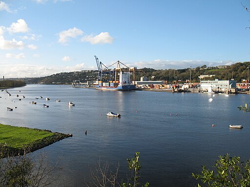
Cork Harbour. A natural harbour and river estuary at the mouth of the River Lee. It is one of several which lay claim to the title of "second largest natural harbour in the world by navigational area" (after Port Jackson, Sydney).
Blackrock Castle. Originally developed as a coastal defence fortification in the 16th century to protect upper Cork Harbour and port, the site now includes a visitor centre, restaurant and observatory. The castle's observatory houses an interactive astronomy center which is open to the public, and has exhibits including a "tour of the universe" and a radio telescope that beams messages composed by school groups towards nearby stars.
Park seen from the Marina. Marina Park is a new contemporary City Park situated within the South Docklands and extending from Shandon Boat Club to Blackrock Harbour with an approximate area of 32ha. The park is central to the redevelopment of the South Docks Area, as it will form the primary parkland area in a high density mixed use residential and business area.
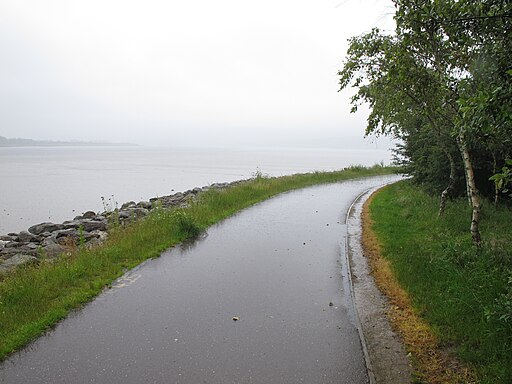
Cycle track from Blackrock by Lough Mahon. This greenway is built on the trackbed of The Cork, Blackrock and Passage West Railway, which opened on 18th June 1850 and closed 10th Sep 1932. First opened as Irish standard gauge (5ft 3in) railway between Cork and Passage West. When the line was extended to Crosshaven in the 1900’s they converted it to narrow gauge (3ft) this was completed in 1904. The greenway is broken into two sections from Blackrock Castle to Passage West and Carrigaline to Crosshaven.
Royal Cork Yacht Club. The Royal Cork Yacht Club, claimed as the world's oldest, was founded as 'The Water Club' on Haulbowline Island in the 1720s. When the British Navy took over Haulbowline in 1801, the club moved to Cobh, where their original clubhouse (built in the 1850s) still stands. In the 1960s, the club moved to Crosshaven. There are also boatyards at Crosshaven and two other marinas. There is another marina on Great Island opposite East Ferry, while Monkstown and Blackrock are used for boating, canoeing, windsurfing and jet-skiing. A number of rowing clubs have facilities on the part of the River Lee between Cork city and Blackrock.
Cork Harbour. The harbour has been a working port and a strategic defensive hub for centuries, and it has been one of Ireland's major employment hubs since the early 1900s. Traditional heavy industries have waned since the late 20th century, with the likes of the closure of Irish Steel in Haulbowline and shipbuilding at Verolme. It still has strategic significance in energy generation, shipping, refining and pharmaceuticals development.


